You are here: Home > Network List > TA - USArray Transportable Network (new EarthScope stations) Stations List
> Station G26K Porcupine River, AK, USA > Earthquake Result Viewer
G26K Porcupine River, AK, USA - Earthquake Result Viewer
| Earthquake location: |
Fiji Islands Region |
| Earthquake latitude/longitude: |
-18.9/-176.2 |
| Earthquake time(UTC): |
2021/04/24 (114) 00:23:36 GMT |
| Earthquake Depth: |
289 km |
| Earthquake Magnitude: |
6.4 Mww |
| Earthquake Catalog/Contributor: |
NEIC PDE/us |
|
| Network: |
TA USArray Transportable Network (new EarthScope stations) |
| Station: |
G26K Porcupine River, AK, USA |
| Lat/Lon: |
66.95 N/143.78 W |
| Elevation: |
180 m |
|
| Distance: |
89.0 deg |
| Az: |
12.2 deg |
| Baz: |
210.532 deg |
| Ray Param: |
0.04172922 |
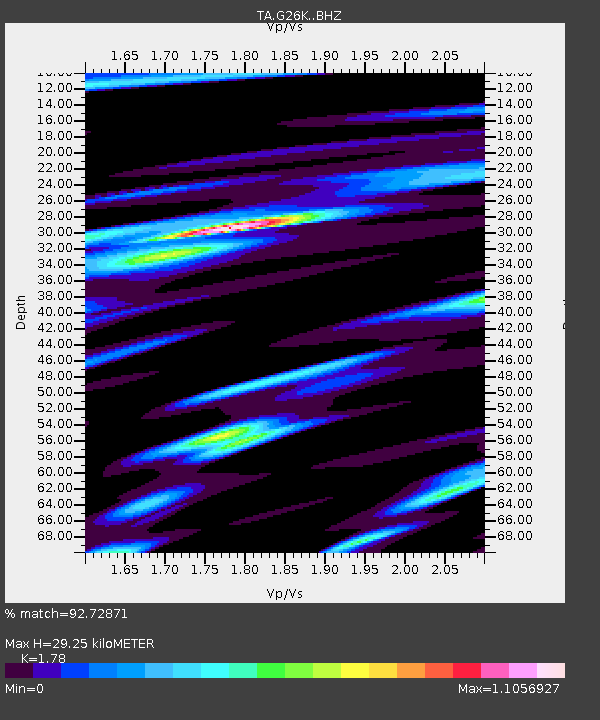
| Estimated Moho Depth: |
29.25 km |
| Estimated Crust Vp/Vs: |
1.78 |
| Assumed Crust Vp: |
6.577 km/s |
| Estimated Crust Vs: |
3.695 km/s |
| Estimated Crust Poisson's Ratio: |
0.27 |
|
| Radial Match: |
92.72871 % |
| Radial Bump: |
315 |
| Transverse Match: |
83.12869 % |
| Transverse Bump: |
398 |
| SOD ConfigId: |
24334971 |
| Insert Time: |
2021-05-08 00:50:28.954 +0000 |
| GWidth: |
2.5 |
| Max Bumps: |
400 |
| Tol: |
0.001 |
|

Signal To Noise
| Channel | StoN | STA | LTA |
| TA:G26K: :BHZ:20210424T00:35:27.475009Z | 21.10427 | 2.210149E-6 | 1.04725196E-7 |
| TA:G26K: :BHN:20210424T00:35:27.475009Z | 10.511683 | 1.0745198E-6 | 1.02221485E-7 |
| TA:G26K: :BHE:20210424T00:35:27.475009Z | 4.501883 | 5.7552955E-7 | 1.2784196E-7 |
| Arrivals |
| Ps | 3.5 SECOND |
| PpPs | 12 SECOND |
| PsPs/PpSs | 16 SECOND |


