You are here: Home > Network List > TA - USArray Transportable Network (new EarthScope stations) Stations List
> Station I20K Naaghedeneel ne tl'uh kk'aat, AK, USA > Earthquake Result Viewer
I20K Naaghedeneel ne tl'uh kk'aat, AK, USA - Earthquake Result Viewer
| Earthquake location: |
Fiji Islands Region |
| Earthquake latitude/longitude: |
-18.9/-176.2 |
| Earthquake time(UTC): |
2021/04/24 (114) 00:23:36 GMT |
| Earthquake Depth: |
289 km |
| Earthquake Magnitude: |
6.4 Mww |
| Earthquake Catalog/Contributor: |
NEIC PDE/us |
|
| Network: |
TA USArray Transportable Network (new EarthScope stations) |
| Station: |
I20K Naaghedeneel ne tl'uh kk'aat, AK, USA |
| Lat/Lon: |
64.80 N/154.48 W |
| Elevation: |
75 m |
|
| Distance: |
85.1 deg |
| Az: |
9.166 deg |
| Baz: |
200.62 deg |
| Ray Param: |
0.044280738 |
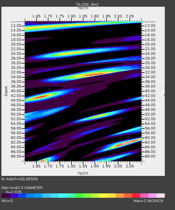
| Estimated Moho Depth: |
62.0 km |
| Estimated Crust Vp/Vs: |
2.04 |
| Assumed Crust Vp: |
6.566 km/s |
| Estimated Crust Vs: |
3.227 km/s |
| Estimated Crust Poisson's Ratio: |
0.34 |
|
| Radial Match: |
80.65506 % |
| Radial Bump: |
400 |
| Transverse Match: |
76.33354 % |
| Transverse Bump: |
400 |
| SOD ConfigId: |
24334971 |
| Insert Time: |
2021-05-08 00:50:43.965 +0000 |
| GWidth: |
2.5 |
| Max Bumps: |
400 |
| Tol: |
0.001 |
|

Signal To Noise
| Channel | StoN | STA | LTA |
| TA:I20K: :BHZ:20210424T00:35:09.175021Z | 18.954142 | 3.1902364E-6 | 1.6831342E-7 |
| TA:I20K: :BHN:20210424T00:35:09.175021Z | 5.4332395 | 1.5981487E-6 | 2.941429E-7 |
| TA:I20K: :BHE:20210424T00:35:09.175021Z | 4.9421883 | 1.2841672E-6 | 2.5983778E-7 |
| Arrivals |
| Ps | 10.0 SECOND |
| PpPs | 28 SECOND |
| PsPs/PpSs | 38 SECOND |


