You are here: Home > Network List > TA - USArray Transportable Network (new EarthScope stations) Stations List
> Station I28M Miner Creek, YT, CAN > Earthquake Result Viewer
I28M Miner Creek, YT, CAN - Earthquake Result Viewer
| Earthquake location: |
Fiji Islands Region |
| Earthquake latitude/longitude: |
-18.9/-176.2 |
| Earthquake time(UTC): |
2021/04/24 (114) 00:23:36 GMT |
| Earthquake Depth: |
289 km |
| Earthquake Magnitude: |
6.4 Mww |
| Earthquake Catalog/Contributor: |
NEIC PDE/us |
|
| Network: |
TA USArray Transportable Network (new EarthScope stations) |
| Station: |
I28M Miner Creek, YT, CAN |
| Lat/Lon: |
65.45 N/139.94 W |
| Elevation: |
1188 m |
|
| Distance: |
88.5 deg |
| Az: |
14.326 deg |
| Baz: |
214.098 deg |
| Ray Param: |
0.04183661 |
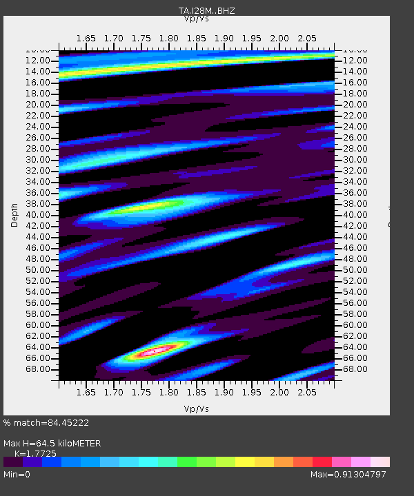
| Estimated Moho Depth: |
64.5 km |
| Estimated Crust Vp/Vs: |
1.77 |
| Assumed Crust Vp: |
6.566 km/s |
| Estimated Crust Vs: |
3.704 km/s |
| Estimated Crust Poisson's Ratio: |
0.27 |
|
| Radial Match: |
84.45222 % |
| Radial Bump: |
391 |
| Transverse Match: |
78.64268 % |
| Transverse Bump: |
400 |
| SOD ConfigId: |
24334971 |
| Insert Time: |
2021-05-08 00:50:45.209 +0000 |
| GWidth: |
2.5 |
| Max Bumps: |
400 |
| Tol: |
0.001 |
|

Signal To Noise
| Channel | StoN | STA | LTA |
| TA:I28M: :BHZ:20210424T00:35:25.449984Z | 18.169922 | 1.9485667E-6 | 1.07241334E-7 |
| TA:I28M: :BHN:20210424T00:35:25.449984Z | 4.9567823 | 4.3961975E-7 | 8.869055E-8 |
| TA:I28M: :BHE:20210424T00:35:25.449984Z | 2.3332984 | 2.676959E-7 | 1.1472853E-7 |
| Arrivals |
| Ps | 7.8 SECOND |
| PpPs | 27 SECOND |
| PsPs/PpSs | 34 SECOND |


