You are here: Home > Network List > TA - USArray Transportable Network (new EarthScope stations) Stations List
> Station J29N Klondike Camp, Yukon, CA > Earthquake Result Viewer
J29N Klondike Camp, Yukon, CA - Earthquake Result Viewer
| Earthquake location: |
Fiji Islands Region |
| Earthquake latitude/longitude: |
-18.9/-176.2 |
| Earthquake time(UTC): |
2021/04/24 (114) 00:23:36 GMT |
| Earthquake Depth: |
289 km |
| Earthquake Magnitude: |
6.4 Mww |
| Earthquake Catalog/Contributor: |
NEIC PDE/us |
|
| Network: |
TA USArray Transportable Network (new EarthScope stations) |
| Station: |
J29N Klondike Camp, Yukon, CA |
| Lat/Lon: |
64.45 N/138.22 W |
| Elevation: |
982 m |
|
| Distance: |
88.1 deg |
| Az: |
15.499 deg |
| Baz: |
215.688 deg |
| Ray Param: |
0.042127643 |
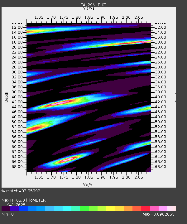
| Estimated Moho Depth: |
65.0 km |
| Estimated Crust Vp/Vs: |
1.76 |
| Assumed Crust Vp: |
6.566 km/s |
| Estimated Crust Vs: |
3.725 km/s |
| Estimated Crust Poisson's Ratio: |
0.26 |
|
| Radial Match: |
87.95892 % |
| Radial Bump: |
400 |
| Transverse Match: |
77.733925 % |
| Transverse Bump: |
400 |
| SOD ConfigId: |
24334971 |
| Insert Time: |
2021-05-08 00:50:53.913 +0000 |
| GWidth: |
2.5 |
| Max Bumps: |
400 |
| Tol: |
0.001 |
|

Signal To Noise
| Channel | StoN | STA | LTA |
| TA:J29N: :BHZ:20210424T00:35:23.574984Z | 24.642235 | 2.7296308E-6 | 1.10770415E-7 |
| TA:J29N: :BHN:20210424T00:35:23.574984Z | 6.2521167 | 9.189228E-7 | 1.4697788E-7 |
| TA:J29N: :BHE:20210424T00:35:23.574984Z | 10.59316 | 6.1856673E-7 | 5.8393038E-8 |
| Arrivals |
| Ps | 7.7 SECOND |
| PpPs | 27 SECOND |
| PsPs/PpSs | 34 SECOND |


