You are here: Home > Network List > TA - USArray Transportable Network (new EarthScope stations) Stations List
> Station J30M Hart River, Yukon, CAN > Earthquake Result Viewer
J30M Hart River, Yukon, CAN - Earthquake Result Viewer
| Earthquake location: |
Fiji Islands Region |
| Earthquake latitude/longitude: |
-18.9/-176.2 |
| Earthquake time(UTC): |
2021/04/24 (114) 00:23:36 GMT |
| Earthquake Depth: |
289 km |
| Earthquake Magnitude: |
6.4 Mww |
| Earthquake Catalog/Contributor: |
NEIC PDE/us |
|
| Network: |
TA USArray Transportable Network (new EarthScope stations) |
| Station: |
J30M Hart River, Yukon, CAN |
| Lat/Lon: |
64.58 N/136.33 W |
| Elevation: |
1419 m |
|
| Distance: |
88.7 deg |
| Az: |
16.081 deg |
| Baz: |
217.404 deg |
| Ray Param: |
0.04173318 |
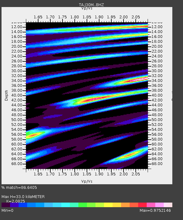
| Estimated Moho Depth: |
33.0 km |
| Estimated Crust Vp/Vs: |
2.08 |
| Assumed Crust Vp: |
6.566 km/s |
| Estimated Crust Vs: |
3.153 km/s |
| Estimated Crust Poisson's Ratio: |
0.35 |
|
| Radial Match: |
86.6405 % |
| Radial Bump: |
352 |
| Transverse Match: |
78.46703 % |
| Transverse Bump: |
362 |
| SOD ConfigId: |
24334971 |
| Insert Time: |
2021-05-08 00:50:54.454 +0000 |
| GWidth: |
2.5 |
| Max Bumps: |
400 |
| Tol: |
0.001 |
|

Signal To Noise
| Channel | StoN | STA | LTA |
| TA:J30M: :BHZ:20210424T00:35:26.300021Z | 15.548731 | 2.0106686E-6 | 1.2931399E-7 |
| TA:J30M: :BHN:20210424T00:35:26.300021Z | 8.560297 | 7.4821116E-7 | 8.7404814E-8 |
| TA:J30M: :BHE:20210424T00:35:26.300021Z | 9.807335 | 6.81758E-7 | 6.951512E-8 |
| Arrivals |
| Ps | 5.5 SECOND |
| PpPs | 15 SECOND |
| PsPs/PpSs | 21 SECOND |


