You are here: Home > Network List > TA - USArray Transportable Network (new EarthScope stations) Stations List
> Station K29M Barlow Dome, YT, CAN > Earthquake Result Viewer
K29M Barlow Dome, YT, CAN - Earthquake Result Viewer
| Earthquake location: |
Fiji Islands Region |
| Earthquake latitude/longitude: |
-18.9/-176.2 |
| Earthquake time(UTC): |
2021/04/24 (114) 00:23:36 GMT |
| Earthquake Depth: |
289 km |
| Earthquake Magnitude: |
6.4 Mww |
| Earthquake Catalog/Contributor: |
NEIC PDE/us |
|
| Network: |
TA USArray Transportable Network (new EarthScope stations) |
| Station: |
K29M Barlow Dome, YT, CAN |
| Lat/Lon: |
63.84 N/137.52 W |
| Elevation: |
1367 m |
|
| Distance: |
87.8 deg |
| Az: |
16.106 deg |
| Baz: |
216.335 deg |
| Ray Param: |
0.042349733 |
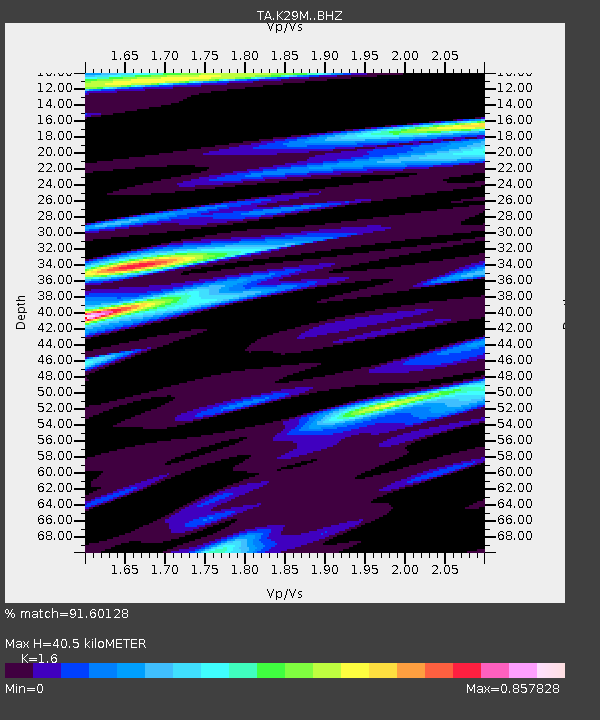
| Estimated Moho Depth: |
40.5 km |
| Estimated Crust Vp/Vs: |
1.60 |
| Assumed Crust Vp: |
6.566 km/s |
| Estimated Crust Vs: |
4.104 km/s |
| Estimated Crust Poisson's Ratio: |
0.18 |
|
| Radial Match: |
91.60128 % |
| Radial Bump: |
400 |
| Transverse Match: |
80.26495 % |
| Transverse Bump: |
344 |
| SOD ConfigId: |
24334971 |
| Insert Time: |
2021-05-08 00:50:57.071 +0000 |
| GWidth: |
2.5 |
| Max Bumps: |
400 |
| Tol: |
0.001 |
|
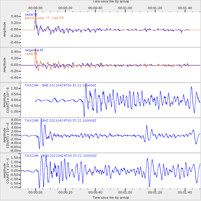
Signal To Noise
| Channel | StoN | STA | LTA |
| TA:K29M: :BHZ:20210424T00:35:22.100009Z | 28.403555 | 3.434757E-6 | 1.2092701E-7 |
| TA:K29M: :BHN:20210424T00:35:22.100009Z | 7.056978 | 9.1660155E-7 | 1.2988585E-7 |
| TA:K29M: :BHE:20210424T00:35:22.100009Z | 8.234424 | 6.0860884E-7 | 7.3910314E-8 |
| Arrivals |
| Ps | 3.8 SECOND |
| PpPs | 16 SECOND |
| PsPs/PpSs | 19 SECOND |


