You are here: Home > Network List > TA - USArray Transportable Network (new EarthScope stations) Stations List
> Station M22K Willow, AK, USA > Earthquake Result Viewer
M22K Willow, AK, USA - Earthquake Result Viewer
| Earthquake location: |
Fiji Islands Region |
| Earthquake latitude/longitude: |
-18.9/-176.2 |
| Earthquake time(UTC): |
2021/04/24 (114) 00:23:36 GMT |
| Earthquake Depth: |
289 km |
| Earthquake Magnitude: |
6.4 Mww |
| Earthquake Catalog/Contributor: |
NEIC PDE/us |
|
| Network: |
TA USArray Transportable Network (new EarthScope stations) |
| Station: |
M22K Willow, AK, USA |
| Lat/Lon: |
61.75 N/150.12 W |
| Elevation: |
57 m |
|
| Distance: |
83.1 deg |
| Az: |
12.178 deg |
| Baz: |
204.819 deg |
| Ray Param: |
0.045717303 |
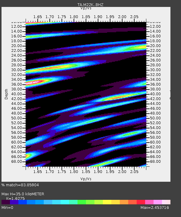
| Estimated Moho Depth: |
35.0 km |
| Estimated Crust Vp/Vs: |
1.63 |
| Assumed Crust Vp: |
6.302 km/s |
| Estimated Crust Vs: |
3.872 km/s |
| Estimated Crust Poisson's Ratio: |
0.20 |
|
| Radial Match: |
83.85904 % |
| Radial Bump: |
400 |
| Transverse Match: |
71.18294 % |
| Transverse Bump: |
338 |
| SOD ConfigId: |
24334971 |
| Insert Time: |
2021-05-08 00:51:08.051 +0000 |
| GWidth: |
2.5 |
| Max Bumps: |
400 |
| Tol: |
0.001 |
|

Signal To Noise
| Channel | StoN | STA | LTA |
| TA:M22K: :BHZ:20210424T00:34:58.925021Z | 31.589102 | 3.4721756E-6 | 1.0991688E-7 |
| TA:M22K: :BHN:20210424T00:34:58.925021Z | 7.413345 | 2.0379305E-6 | 2.749003E-7 |
| TA:M22K: :BHE:20210424T00:34:58.925021Z | 5.353549 | 1.1854083E-6 | 2.2142477E-7 |
| Arrivals |
| Ps | 3.6 SECOND |
| PpPs | 14 SECOND |
| PsPs/PpSs | 18 SECOND |


