You are here: Home > Network List > TX - Texas Seismological Network Stations List
> Station MB05 Klondike > Earthquake Result Viewer
MB05 Klondike - Earthquake Result Viewer
| Earthquake location: |
Fiji Islands Region |
| Earthquake latitude/longitude: |
-18.9/-176.2 |
| Earthquake time(UTC): |
2021/04/24 (114) 00:23:36 GMT |
| Earthquake Depth: |
289 km |
| Earthquake Magnitude: |
6.4 Mww |
| Earthquake Catalog/Contributor: |
NEIC PDE/us |
|
| Network: |
TX Texas Seismological Network |
| Station: |
MB05 Klondike |
| Lat/Lon: |
32.63 N/101.86 W |
| Elevation: |
882 m |
|
| Distance: |
87.6 deg |
| Az: |
54.428 deg |
| Baz: |
245.848 deg |
| Ray Param: |
0.042506866 |
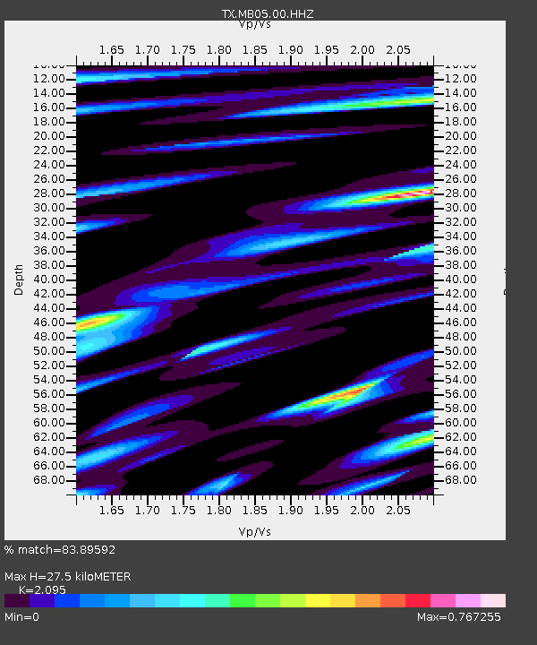
| Estimated Moho Depth: |
27.5 km |
| Estimated Crust Vp/Vs: |
2.10 |
| Assumed Crust Vp: |
6.426 km/s |
| Estimated Crust Vs: |
3.067 km/s |
| Estimated Crust Poisson's Ratio: |
0.35 |
|
| Radial Match: |
83.89592 % |
| Radial Bump: |
400 |
| Transverse Match: |
76.69944 % |
| Transverse Bump: |
400 |
| SOD ConfigId: |
24334971 |
| Insert Time: |
2021-05-08 00:52:52.148 +0000 |
| GWidth: |
2.5 |
| Max Bumps: |
400 |
| Tol: |
0.001 |
|

Signal To Noise
| Channel | StoN | STA | LTA |
| TX:MB05:00:HHZ:20210424T00:35:21.069979Z | 13.649925 | 1.3741303E-6 | 1.0066943E-7 |
| TX:MB05:00:HH1:20210424T00:35:21.069979Z | 0.57337695 | 7.734539E-8 | 1.3489448E-7 |
| TX:MB05:00:HH2:20210424T00:35:21.069979Z | 1.7693398 | 2.5412388E-7 | 1.4362638E-7 |
| Arrivals |
| Ps | 4.8 SECOND |
| PpPs | 13 SECOND |
| PsPs/PpSs | 18 SECOND |


