You are here: Home > Network List > TX - Texas Seismological Network Stations List
> Station MNHN Monahans > Earthquake Result Viewer
MNHN Monahans - Earthquake Result Viewer
| Earthquake location: |
Fiji Islands Region |
| Earthquake latitude/longitude: |
-18.9/-176.2 |
| Earthquake time(UTC): |
2021/04/24 (114) 00:23:36 GMT |
| Earthquake Depth: |
289 km |
| Earthquake Magnitude: |
6.4 Mww |
| Earthquake Catalog/Contributor: |
NEIC PDE/us |
|
| Network: |
TX Texas Seismological Network |
| Station: |
MNHN Monahans |
| Lat/Lon: |
31.34 N/102.76 W |
| Elevation: |
750 m |
|
| Distance: |
86.4 deg |
| Az: |
55.281 deg |
| Baz: |
245.418 deg |
| Ray Param: |
0.043391053 |
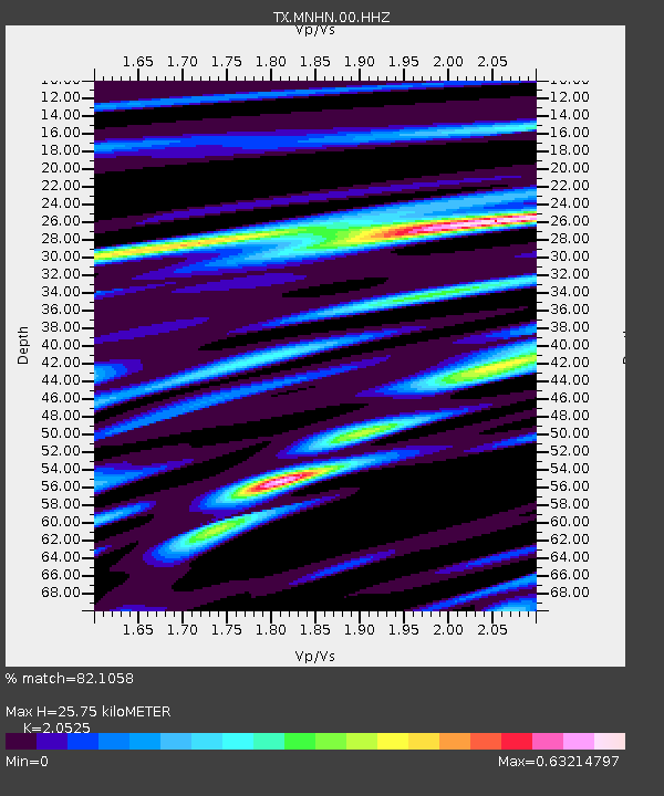
| Estimated Moho Depth: |
25.75 km |
| Estimated Crust Vp/Vs: |
2.05 |
| Assumed Crust Vp: |
6.121 km/s |
| Estimated Crust Vs: |
2.982 km/s |
| Estimated Crust Poisson's Ratio: |
0.34 |
|
| Radial Match: |
82.1058 % |
| Radial Bump: |
400 |
| Transverse Match: |
75.62149 % |
| Transverse Bump: |
343 |
| SOD ConfigId: |
24334971 |
| Insert Time: |
2021-05-08 00:52:57.920 +0000 |
| GWidth: |
2.5 |
| Max Bumps: |
400 |
| Tol: |
0.001 |
|

Signal To Noise
| Channel | StoN | STA | LTA |
| TX:MNHN:00:HHZ:20210424T00:35:15.214999Z | 7.963617 | 2.2424497E-6 | 2.815868E-7 |
| TX:MNHN:00:HH1:20210424T00:35:15.214999Z | 4.964158 | 6.314197E-7 | 1.2719573E-7 |
| TX:MNHN:00:HH2:20210424T00:35:15.214999Z | 1.6233375 | 2.613196E-7 | 1.6097675E-7 |
| Arrivals |
| Ps | 4.5 SECOND |
| PpPs | 13 SECOND |
| PsPs/PpSs | 17 SECOND |


