You are here: Home > Network List > US - United States National Seismic Network Stations List
> Station DGMT Dagmar, Montana, USA > Earthquake Result Viewer
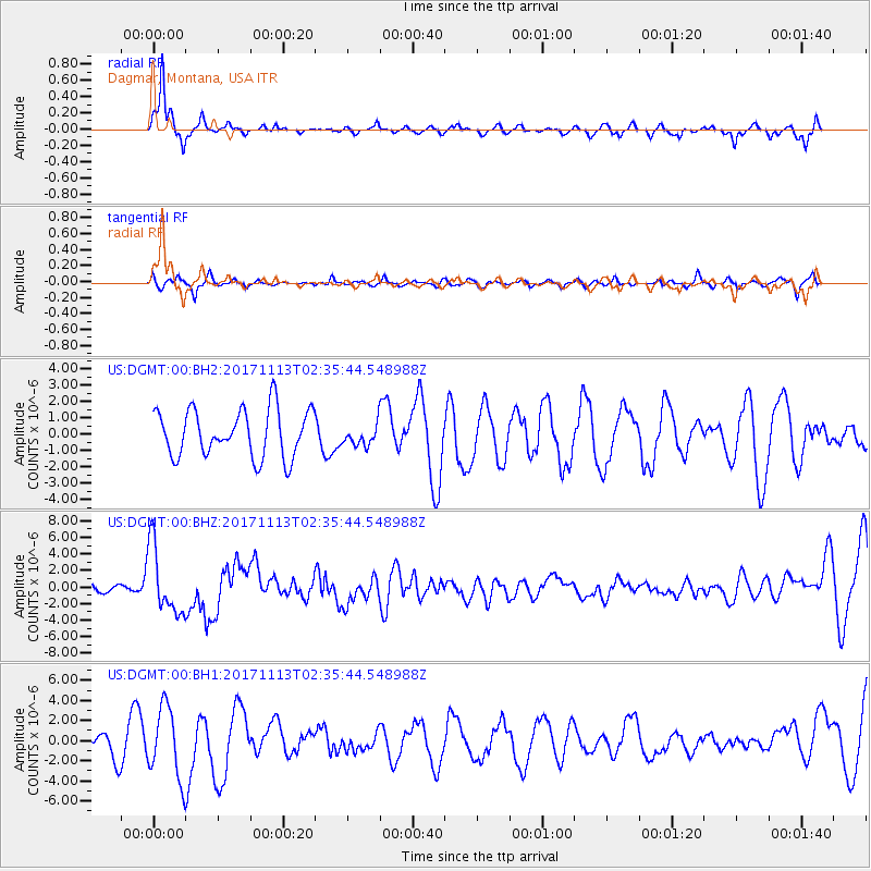
DGMT Dagmar, Montana, USA - Earthquake Result Viewer
*The percent match for this event was below the threshold and hence no stack was calculated.
| Earthquake location: |
Costa Rica |
| Earthquake latitude/longitude: |
9.5/-84.5 |
| Earthquake time(UTC): |
2017/11/13 (317) 02:28:23 GMT |
| Earthquake Depth: |
19 km |
| Earthquake Magnitude: |
6.5 mww |
| Earthquake Catalog/Contributor: |
NEIC PDE/us |
|
| Network: |
US United States National Seismic Network |
| Station: |
DGMT Dagmar, Montana, USA |
| Lat/Lon: |
48.47 N/104.20 W |
| Elevation: |
0.0 m |
|
| Distance: |
42.2 deg |
| Az: |
340.488 deg |
| Baz: |
150.326 deg |
| Ray Param: |
$rayparam |
*The percent match for this event was below the threshold and hence was not used in the summary stack. |
|
| Radial Match: |
81.498085 % |
| Radial Bump: |
296 |
| Transverse Match: |
40.068836 % |
| Transverse Bump: |
339 |
| SOD ConfigId: |
2429771 |
| Insert Time: |
2017-11-27 02:31:19.327 +0000 |
| GWidth: |
2.5 |
| Max Bumps: |
400 |
| Tol: |
0.001 |
|
Signal To Noise
| Channel | StoN | STA | LTA |
| US:DGMT:00:BHZ:20171113T02:35:44.548988Z | 9.671303 | 4.0767777E-6 | 4.2153349E-7 |
| US:DGMT:00:BH1:20171113T02:35:44.548988Z | 3.0586305 | 3.523175E-6 | 1.1518799E-6 |
| US:DGMT:00:BH2:20171113T02:35:44.548988Z | 0.44760406 | 6.4403724E-7 | 1.4388547E-6 |
| Arrivals |
| Ps | |
| PpPs | |
| PsPs/PpSs | |


