You are here: Home > Network List > US - United States National Seismic Network Stations List
> Station EGMT Eagleton, Montana, USA > Earthquake Result Viewer
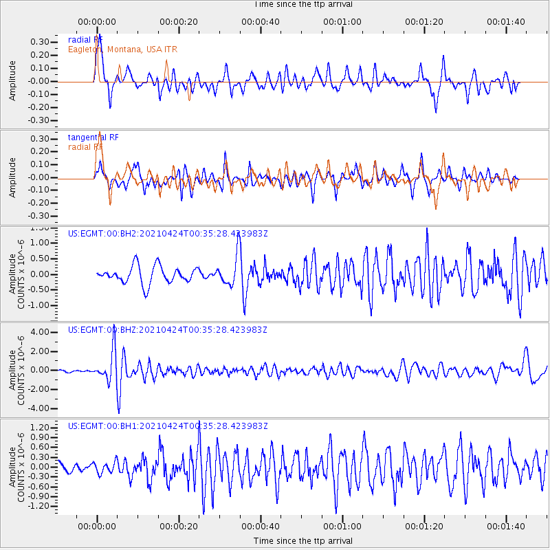
EGMT Eagleton, Montana, USA - Earthquake Result Viewer
*The percent match for this event was below the threshold and hence no stack was calculated.
| Earthquake location: |
Fiji Islands Region |
| Earthquake latitude/longitude: |
-18.9/-176.2 |
| Earthquake time(UTC): |
2021/04/24 (114) 00:23:36 GMT |
| Earthquake Depth: |
289 km |
| Earthquake Magnitude: |
6.4 Mww |
| Earthquake Catalog/Contributor: |
NEIC PDE/us |
|
| Network: |
US United States National Seismic Network |
| Station: |
EGMT Eagleton, Montana, USA |
| Lat/Lon: |
48.02 N/109.75 W |
| Elevation: |
1055 m |
|
| Distance: |
89.2 deg |
| Az: |
37.995 deg |
| Baz: |
240.237 deg |
| Ray Param: |
$rayparam |
*The percent match for this event was below the threshold and hence was not used in the summary stack. |
|
| Radial Match: |
71.35894 % |
| Radial Bump: |
400 |
| Transverse Match: |
65.2164 % |
| Transverse Bump: |
348 |
| SOD ConfigId: |
24334971 |
| Insert Time: |
2021-05-08 00:54:48.921 +0000 |
| GWidth: |
2.5 |
| Max Bumps: |
400 |
| Tol: |
0.001 |
|
Signal To Noise
| Channel | StoN | STA | LTA |
| US:EGMT:00:BHZ:20210424T00:35:28.423983Z | 10.350983 | 1.6528185E-6 | 1.5967746E-7 |
| US:EGMT:00:BH1:20210424T00:35:28.423983Z | 1.0504864 | 1.7486047E-7 | 1.6645669E-7 |
| US:EGMT:00:BH2:20210424T00:35:28.423983Z | 1.832351 | 4.973524E-7 | 2.7142858E-7 |
| Arrivals |
| Ps | |
| PpPs | |
| PsPs/PpSs | |


