You are here: Home > Network List > US - United States National Seismic Network Stations List
> Station MIAR Mount Ida, Arkansas, USA > Earthquake Result Viewer
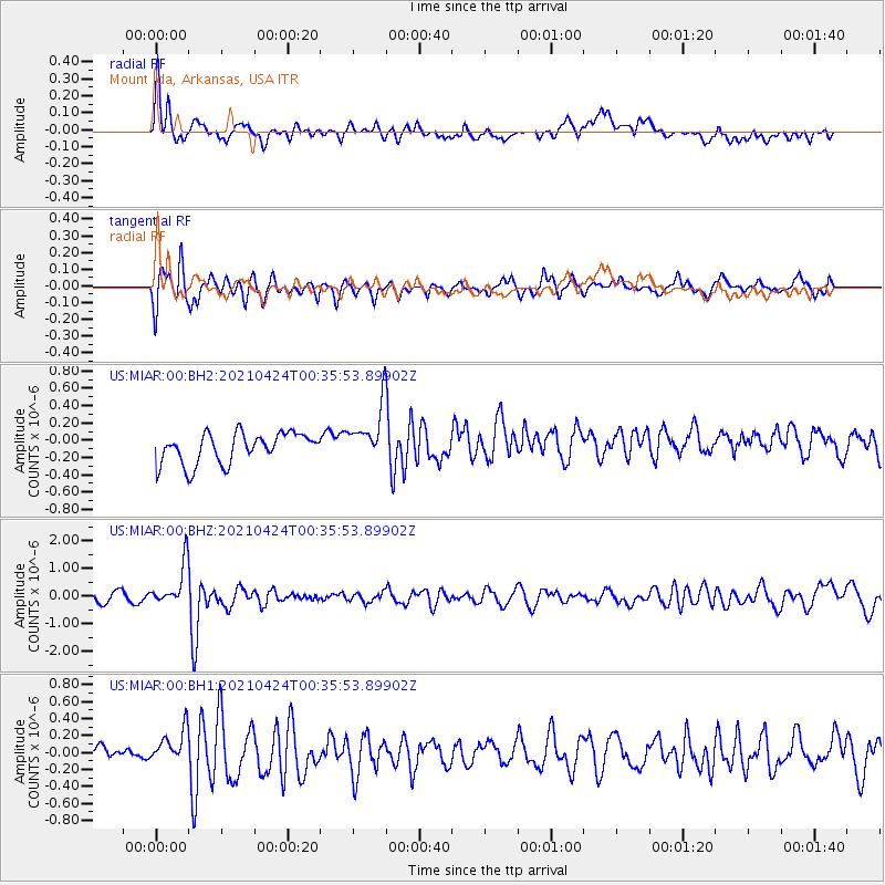
MIAR Mount Ida, Arkansas, USA - Earthquake Result Viewer
*The percent match for this event was below the threshold and hence no stack was calculated.
| Earthquake location: |
Fiji Islands Region |
| Earthquake latitude/longitude: |
-18.9/-176.2 |
| Earthquake time(UTC): |
2021/04/24 (114) 00:23:36 GMT |
| Earthquake Depth: |
289 km |
| Earthquake Magnitude: |
6.4 Mww |
| Earthquake Catalog/Contributor: |
NEIC PDE/us |
|
| Network: |
US United States National Seismic Network |
| Station: |
MIAR Mount Ida, Arkansas, USA |
| Lat/Lon: |
34.55 N/93.58 W |
| Elevation: |
207 m |
|
| Distance: |
94.7 deg |
| Az: |
55.231 deg |
| Baz: |
250.399 deg |
| Ray Param: |
$rayparam |
*The percent match for this event was below the threshold and hence was not used in the summary stack. |
|
| Radial Match: |
64.09293 % |
| Radial Bump: |
400 |
| Transverse Match: |
72.3601 % |
| Transverse Bump: |
360 |
| SOD ConfigId: |
24334971 |
| Insert Time: |
2021-05-08 00:55:02.421 +0000 |
| GWidth: |
2.5 |
| Max Bumps: |
400 |
| Tol: |
0.001 |
|
Signal To Noise
| Channel | StoN | STA | LTA |
| US:MIAR:00:BHZ:20210424T00:35:53.89902Z | 2.7797341 | 7.6634484E-7 | 2.7568996E-7 |
| US:MIAR:00:BH1:20210424T00:35:53.89902Z | 2.176429 | 2.1569082E-7 | 9.9103076E-8 |
| US:MIAR:00:BH2:20210424T00:35:53.89902Z | 1.8363901 | 3.2079606E-7 | 1.7468841E-7 |
| Arrivals |
| Ps | |
| PpPs | |
| PsPs/PpSs | |


