You are here: Home > Network List > US - United States National Seismic Network Stations List
> Station ERPA Erie, Pennsylvania, USA > Earthquake Result Viewer
ERPA Erie, Pennsylvania, USA - Earthquake Result Viewer
| Earthquake location: |
Costa Rica |
| Earthquake latitude/longitude: |
9.5/-84.5 |
| Earthquake time(UTC): |
2017/11/13 (317) 02:28:23 GMT |
| Earthquake Depth: |
19 km |
| Earthquake Magnitude: |
6.5 mww |
| Earthquake Catalog/Contributor: |
NEIC PDE/us |
|
| Network: |
US United States National Seismic Network |
| Station: |
ERPA Erie, Pennsylvania, USA |
| Lat/Lon: |
42.12 N/79.99 W |
| Elevation: |
306 m |
|
| Distance: |
32.7 deg |
| Az: |
6.197 deg |
| Baz: |
188.228 deg |
| Ray Param: |
0.07851583 |
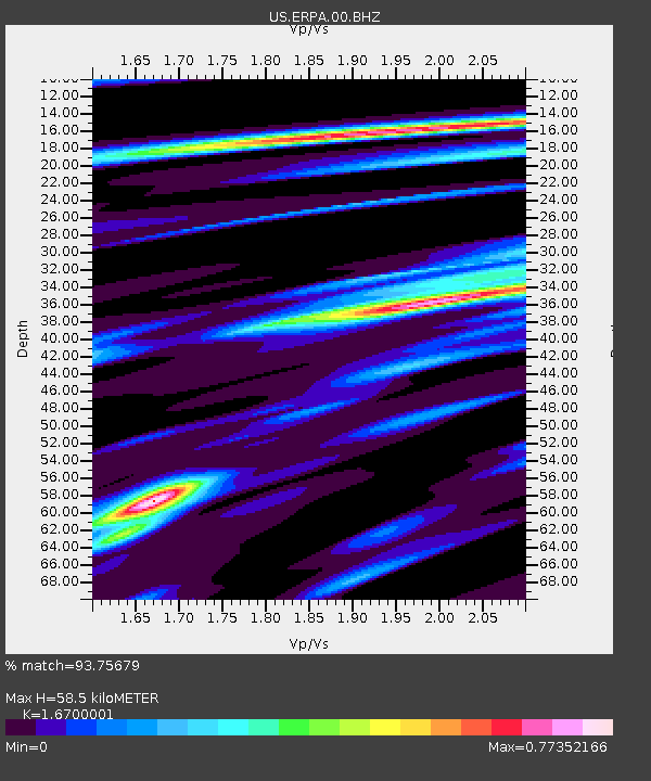
| Estimated Moho Depth: |
58.5 km |
| Estimated Crust Vp/Vs: |
1.67 |
| Assumed Crust Vp: |
6.419 km/s |
| Estimated Crust Vs: |
3.844 km/s |
| Estimated Crust Poisson's Ratio: |
0.22 |
|
| Radial Match: |
93.75679 % |
| Radial Bump: |
206 |
| Transverse Match: |
49.726536 % |
| Transverse Bump: |
400 |
| SOD ConfigId: |
2429771 |
| Insert Time: |
2017-11-27 02:31:26.941 +0000 |
| GWidth: |
2.5 |
| Max Bumps: |
400 |
| Tol: |
0.001 |
|

Signal To Noise
| Channel | StoN | STA | LTA |
| US:ERPA:00:BHZ:20171113T02:34:24.250007Z | 17.96059 | 5.4758507E-6 | 3.0488147E-7 |
| US:ERPA:00:BH1:20171113T02:34:24.250007Z | 10.992197 | 3.2240696E-6 | 2.933053E-7 |
| US:ERPA:00:BH2:20171113T02:34:24.250007Z | 2.215108 | 7.8098276E-7 | 3.5257096E-7 |
| Arrivals |
| Ps | 6.6 SECOND |
| PpPs | 22 SECOND |
| PsPs/PpSs | 29 SECOND |


