You are here: Home > Network List > US - United States National Seismic Network Stations List
> Station OGNE Ogallala, Nebraska, USA > Earthquake Result Viewer
OGNE Ogallala, Nebraska, USA - Earthquake Result Viewer
| Earthquake location: |
Costa Rica |
| Earthquake latitude/longitude: |
9.5/-84.5 |
| Earthquake time(UTC): |
2017/11/13 (317) 02:28:23 GMT |
| Earthquake Depth: |
19 km |
| Earthquake Magnitude: |
6.5 mww |
| Earthquake Catalog/Contributor: |
NEIC PDE/us |
|
| Network: |
US United States National Seismic Network |
| Station: |
OGNE Ogallala, Nebraska, USA |
| Lat/Lon: |
40.95 N/102.03 W |
| Elevation: |
1054 m |
|
| Distance: |
34.9 deg |
| Az: |
336.505 deg |
| Baz: |
148.725 deg |
| Ray Param: |
0.07745584 |
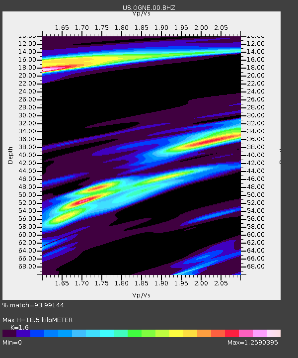
| Estimated Moho Depth: |
18.5 km |
| Estimated Crust Vp/Vs: |
1.60 |
| Assumed Crust Vp: |
6.483 km/s |
| Estimated Crust Vs: |
4.052 km/s |
| Estimated Crust Poisson's Ratio: |
0.18 |
|
| Radial Match: |
93.99144 % |
| Radial Bump: |
209 |
| Transverse Match: |
75.28997 % |
| Transverse Bump: |
282 |
| SOD ConfigId: |
2429771 |
| Insert Time: |
2017-11-27 02:31:50.026 +0000 |
| GWidth: |
2.5 |
| Max Bumps: |
400 |
| Tol: |
0.001 |
|
Signal To Noise
| Channel | StoN | STA | LTA |
| US:OGNE:00:BHZ:20171113T02:34:43.625007Z | 12.523916 | 4.0116415E-6 | 3.2031846E-7 |
| US:OGNE:00:BH1:20171113T02:34:43.625007Z | 5.2994943 | 2.6853454E-6 | 5.067173E-7 |
| US:OGNE:00:BH2:20171113T02:34:43.625007Z | 3.3706622 | 2.4370177E-6 | 7.2300855E-7 |
| Arrivals |
| Ps | 1.9 SECOND |
| PpPs | 6.8 SECOND |
| PsPs/PpSs | 8.7 SECOND |


