You are here: Home > Network List > US - United States National Seismic Network Stations List
> Station TPNV Topopah Spring, Nevada, USA > Earthquake Result Viewer
TPNV Topopah Spring, Nevada, USA - Earthquake Result Viewer
| Earthquake location: |
Costa Rica |
| Earthquake latitude/longitude: |
9.5/-84.5 |
| Earthquake time(UTC): |
2017/11/13 (317) 02:28:23 GMT |
| Earthquake Depth: |
19 km |
| Earthquake Magnitude: |
6.5 mww |
| Earthquake Catalog/Contributor: |
NEIC PDE/us |
|
| Network: |
US United States National Seismic Network |
| Station: |
TPNV Topopah Spring, Nevada, USA |
| Lat/Lon: |
36.95 N/116.25 W |
| Elevation: |
1600 m |
|
| Distance: |
39.6 deg |
| Az: |
318.612 deg |
| Baz: |
125.502 deg |
| Ray Param: |
0.0748495 |
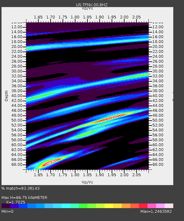
| Estimated Moho Depth: |
66.75 km |
| Estimated Crust Vp/Vs: |
1.70 |
| Assumed Crust Vp: |
6.279 km/s |
| Estimated Crust Vs: |
3.688 km/s |
| Estimated Crust Poisson's Ratio: |
0.24 |
|
| Radial Match: |
93.39143 % |
| Radial Bump: |
400 |
| Transverse Match: |
82.15796 % |
| Transverse Bump: |
400 |
| SOD ConfigId: |
2429771 |
| Insert Time: |
2017-11-27 02:31:57.137 +0000 |
| GWidth: |
2.5 |
| Max Bumps: |
400 |
| Tol: |
0.001 |
|
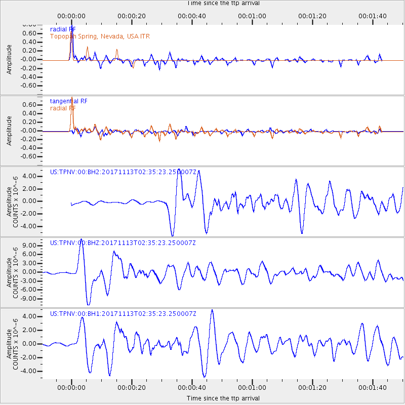
Signal To Noise
| Channel | StoN | STA | LTA |
| US:TPNV:00:BHZ:20171113T02:35:23.250007Z | 28.588816 | 5.2971495E-6 | 1.8528748E-7 |
| US:TPNV:00:BH1:20171113T02:35:23.250007Z | 13.76425 | 1.957214E-6 | 1.4219547E-7 |
| US:TPNV:00:BH2:20171113T02:35:23.250007Z | 12.446979 | 2.5581844E-6 | 2.0552653E-7 |
| Arrivals |
| Ps | 8.0 SECOND |
| PpPs | 27 SECOND |
| PsPs/PpSs | 35 SECOND |


