You are here: Home > Network List > AE - Arizona Broadband Seismic Network Stations List
> Station 113A Mohawk Valley, Roll, AZ, USA > Earthquake Result Viewer
113A Mohawk Valley, Roll, AZ, USA - Earthquake Result Viewer
| Earthquake location: |
Fiji Islands Region |
| Earthquake latitude/longitude: |
-21.7/-177.1 |
| Earthquake time(UTC): |
2021/04/25 (115) 22:28:00 GMT |
| Earthquake Depth: |
234 km |
| Earthquake Magnitude: |
6.4 Mww |
| Earthquake Catalog/Contributor: |
NEIC PDE/us |
|
| Network: |
AE Arizona Broadband Seismic Network |
| Station: |
113A Mohawk Valley, Roll, AZ, USA |
| Lat/Lon: |
32.77 N/113.77 W |
| Elevation: |
118 m |
|
| Distance: |
81.1 deg |
| Az: |
49.621 deg |
| Baz: |
237.24 deg |
| Ray Param: |
0.047208447 |
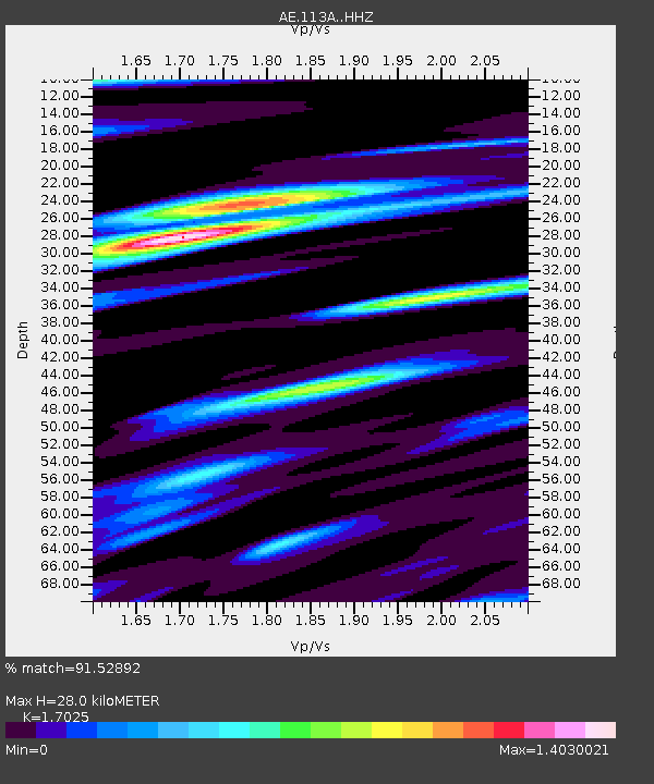
| Estimated Moho Depth: |
28.0 km |
| Estimated Crust Vp/Vs: |
1.70 |
| Assumed Crust Vp: |
6.264 km/s |
| Estimated Crust Vs: |
3.679 km/s |
| Estimated Crust Poisson's Ratio: |
0.24 |
|
| Radial Match: |
91.52892 % |
| Radial Bump: |
292 |
| Transverse Match: |
80.57329 % |
| Transverse Bump: |
396 |
| SOD ConfigId: |
24334971 |
| Insert Time: |
2021-05-09 22:31:45.574 +0000 |
| GWidth: |
2.5 |
| Max Bumps: |
400 |
| Tol: |
0.001 |
|

Signal To Noise
| Channel | StoN | STA | LTA |
| AE:113A: :HHZ:20210425T22:39:18.450025Z | 38.07017 | 2.5237186E-6 | 6.629123E-8 |
| AE:113A: :HHN:20210425T22:39:18.450025Z | 4.751182 | 3.1004964E-7 | 6.5257375E-8 |
| AE:113A: :HHE:20210425T22:39:18.450025Z | 8.182662 | 7.4326067E-7 | 9.08336E-8 |
| Arrivals |
| Ps | 3.2 SECOND |
| PpPs | 12 SECOND |
| PsPs/PpSs | 15 SECOND |


