You are here: Home > Network List > XW97 - Tien Shan Continental Dynamics Stations List
> Station KDJ XW.KDJ > Earthquake Result Viewer
KDJ XW.KDJ - Earthquake Result Viewer
| Earthquake location: |
Hokkaido, Japan Region |
| Earthquake latitude/longitude: |
43.8/145.0 |
| Earthquake time(UTC): |
1997/11/15 (319) 07:05:16 GMT |
| Earthquake Depth: |
161 km |
| Earthquake Magnitude: |
5.8 MB, 6.1 UNKNOWN, 6.1 MW |
| Earthquake Catalog/Contributor: |
WHDF/NEIC |
|
| Network: |
XW Tien Shan Continental Dynamics |
| Station: |
KDJ XW.KDJ |
| Lat/Lon: |
42.13 N/77.19 E |
| Elevation: |
1783 m |
|
| Distance: |
48.4 deg |
| Az: |
292.847 deg |
| Baz: |
63.751 deg |
| Ray Param: |
0.06880896 |
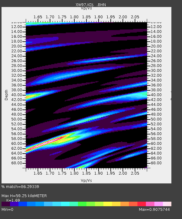
| Estimated Moho Depth: |
59.25 km |
| Estimated Crust Vp/Vs: |
1.69 |
| Assumed Crust Vp: |
6.306 km/s |
| Estimated Crust Vs: |
3.731 km/s |
| Estimated Crust Poisson's Ratio: |
0.23 |
|
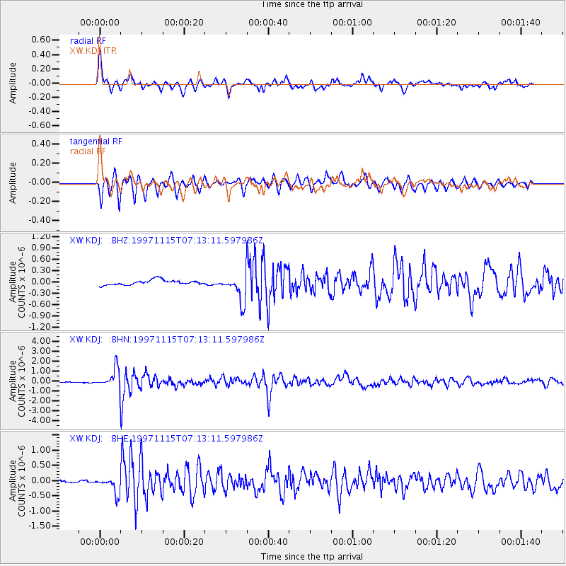
| Radial Match: |
86.29339 % |
| Radial Bump: |
400 |
| Transverse Match: |
85.94911 % |
| Transverse Bump: |
392 |
| SOD ConfigId: |
4480 |
| Insert Time: |
2010-02-26 15:31:53.132 +0000 |
| GWidth: |
2.5 |
| Max Bumps: |
400 |
| Tol: |
0.001 |
|
Signal To Noise
| Channel | StoN | STA | LTA |
| XW:KDJ: :BHN:19971115T07:13:11.597986Z | 18.665764 | 1.0496474E-6 | 5.6233834E-8 |
| XW:KDJ: :BHE:19971115T07:13:11.597986Z | 10.973084 | 2.845256E-7 | 2.5929412E-8 |
| XW:KDJ: :BHZ:19971115T07:13:11.597986Z | 5.9483624 | 3.8026383E-7 | 6.392748E-8 |
| Arrivals |
| Ps | 6.9 SECOND |
| PpPs | 24 SECOND |
| PsPs/PpSs | 31 SECOND |


