You are here: Home > Network List > AK - Alaska Regional Network Stations List
> Station U33K Whale Pass, AK, USA > Earthquake Result Viewer
U33K Whale Pass, AK, USA - Earthquake Result Viewer
| Earthquake location: |
Fiji Islands Region |
| Earthquake latitude/longitude: |
-21.7/-177.1 |
| Earthquake time(UTC): |
2021/04/25 (115) 22:28:00 GMT |
| Earthquake Depth: |
234 km |
| Earthquake Magnitude: |
6.4 Mww |
| Earthquake Catalog/Contributor: |
NEIC PDE/us |
|
| Network: |
AK Alaska Regional Network |
| Station: |
U33K Whale Pass, AK, USA |
| Lat/Lon: |
56.11 N/133.12 W |
| Elevation: |
11 m |
|
| Distance: |
85.9 deg |
| Az: |
22.934 deg |
| Baz: |
220.319 deg |
| Ray Param: |
0.04384733 |
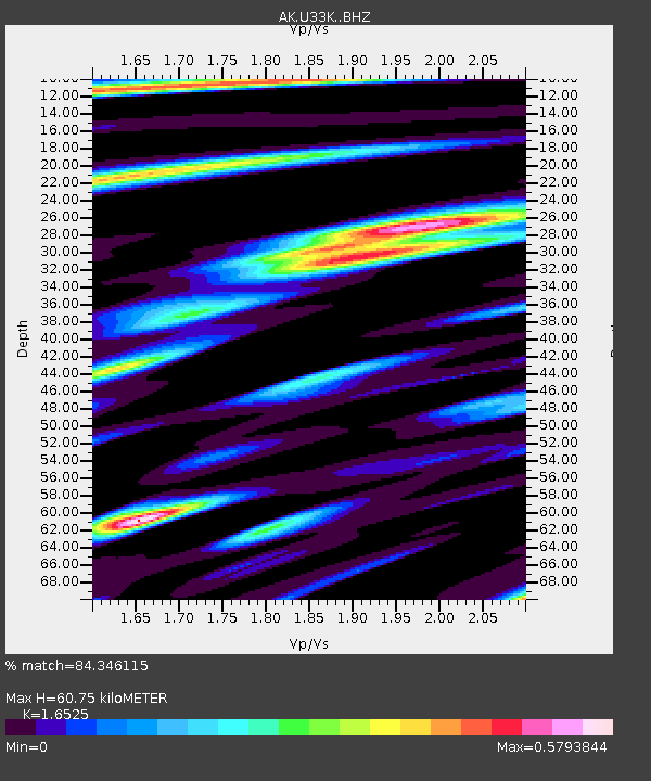
| Estimated Moho Depth: |
60.75 km |
| Estimated Crust Vp/Vs: |
1.65 |
| Assumed Crust Vp: |
6.597 km/s |
| Estimated Crust Vs: |
3.992 km/s |
| Estimated Crust Poisson's Ratio: |
0.21 |
|
| Radial Match: |
84.346115 % |
| Radial Bump: |
380 |
| Transverse Match: |
59.882256 % |
| Transverse Bump: |
400 |
| SOD ConfigId: |
24334971 |
| Insert Time: |
2021-05-09 22:35:02.110 +0000 |
| GWidth: |
2.5 |
| Max Bumps: |
400 |
| Tol: |
0.001 |
|

Signal To Noise
| Channel | StoN | STA | LTA |
| AK:U33K: :BHZ:20210425T22:39:42.779981Z | 9.107369 | 1.306354E-6 | 1.4343922E-7 |
| AK:U33K: :BHN:20210425T22:39:42.779981Z | 2.8751829 | 2.6728108E-7 | 9.2961415E-8 |
| AK:U33K: :BHE:20210425T22:39:42.779981Z | 2.37442 | 2.9845228E-7 | 1.2569483E-7 |
| Arrivals |
| Ps | 6.2 SECOND |
| PpPs | 24 SECOND |
| PsPs/PpSs | 30 SECOND |


