You are here: Home > Network List > AK - Alaska Regional Network Stations List
> Station N15K Kwethluk River, AK, USA > Earthquake Result Viewer
N15K Kwethluk River, AK, USA - Earthquake Result Viewer
| Earthquake location: |
Fiji Islands Region |
| Earthquake latitude/longitude: |
-21.7/-177.1 |
| Earthquake time(UTC): |
2021/04/25 (115) 22:28:00 GMT |
| Earthquake Depth: |
234 km |
| Earthquake Magnitude: |
6.4 Mww |
| Earthquake Catalog/Contributor: |
NEIC PDE/us |
|
| Network: |
AK Alaska Regional Network |
| Station: |
N15K Kwethluk River, AK, USA |
| Lat/Lon: |
60.17 N/160.09 W |
| Elevation: |
449 m |
|
| Distance: |
82.7 deg |
| Az: |
8.46 deg |
| Baz: |
195.884 deg |
| Ray Param: |
0.046109024 |
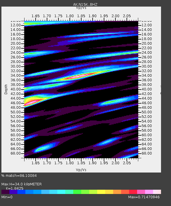
| Estimated Moho Depth: |
34.0 km |
| Estimated Crust Vp/Vs: |
1.84 |
| Assumed Crust Vp: |
6.182 km/s |
| Estimated Crust Vs: |
3.355 km/s |
| Estimated Crust Poisson's Ratio: |
0.29 |
|
| Radial Match: |
86.10084 % |
| Radial Bump: |
400 |
| Transverse Match: |
69.84163 % |
| Transverse Bump: |
380 |
| SOD ConfigId: |
24334971 |
| Insert Time: |
2021-05-09 22:36:18.328 +0000 |
| GWidth: |
2.5 |
| Max Bumps: |
400 |
| Tol: |
0.001 |
|

Signal To Noise
| Channel | StoN | STA | LTA |
| AK:N15K: :BHZ:20210425T22:39:26.740003Z | 20.086132 | 3.0855792E-6 | 1.5361739E-7 |
| AK:N15K: :BHN:20210425T22:39:26.740003Z | 7.993915 | 1.2781618E-6 | 1.5989183E-7 |
| AK:N15K: :BHE:20210425T22:39:26.740003Z | 3.0639994 | 5.262817E-7 | 1.7176299E-7 |
| Arrivals |
| Ps | 4.7 SECOND |
| PpPs | 15 SECOND |
| PsPs/PpSs | 20 SECOND |


