You are here: Home > Network List > AZ - ANZA Regional Network Stations List
> Station RRSP RRSP, CA, USA > Earthquake Result Viewer
RRSP RRSP, CA, USA - Earthquake Result Viewer
| Earthquake location: |
Fiji Islands Region |
| Earthquake latitude/longitude: |
-21.7/-177.1 |
| Earthquake time(UTC): |
2021/04/25 (115) 22:28:00 GMT |
| Earthquake Depth: |
234 km |
| Earthquake Magnitude: |
6.4 Mww |
| Earthquake Catalog/Contributor: |
NEIC PDE/us |
|
| Network: |
AZ ANZA Regional Network |
| Station: |
RRSP RRSP, CA, USA |
| Lat/Lon: |
33.65 N/116.74 W |
| Elevation: |
1610 m |
|
| Distance: |
79.5 deg |
| Az: |
47.474 deg |
| Baz: |
235.258 deg |
| Ray Param: |
0.048292268 |
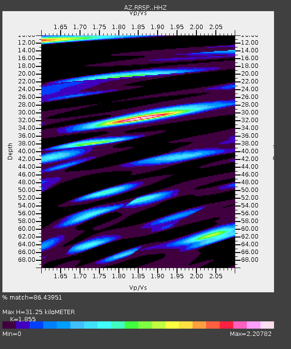
| Estimated Moho Depth: |
31.25 km |
| Estimated Crust Vp/Vs: |
1.86 |
| Assumed Crust Vp: |
6.264 km/s |
| Estimated Crust Vs: |
3.377 km/s |
| Estimated Crust Poisson's Ratio: |
0.30 |
|
| Radial Match: |
86.43951 % |
| Radial Bump: |
400 |
| Transverse Match: |
79.50964 % |
| Transverse Bump: |
400 |
| SOD ConfigId: |
24334971 |
| Insert Time: |
2021-05-09 22:40:15.942 +0000 |
| GWidth: |
2.5 |
| Max Bumps: |
400 |
| Tol: |
0.001 |
|

Signal To Noise
| Channel | StoN | STA | LTA |
| AZ:RRSP: :HHZ:20210425T22:39:10.068982Z | 20.065626 | 2.927625E-6 | 1.459025E-7 |
| AZ:RRSP: :HHN:20210425T22:39:10.068982Z | 5.1003795 | 7.090535E-7 | 1.3901975E-7 |
| AZ:RRSP: :HHE:20210425T22:39:10.068982Z | 6.1806464 | 8.969373E-7 | 1.4512031E-7 |
| Arrivals |
| Ps | 4.4 SECOND |
| PpPs | 14 SECOND |
| PsPs/PpSs | 18 SECOND |


