You are here: Home > Network List > GS - US Geological Survey Networks Stations List
> Station KAN10 Keim Farm > Earthquake Result Viewer
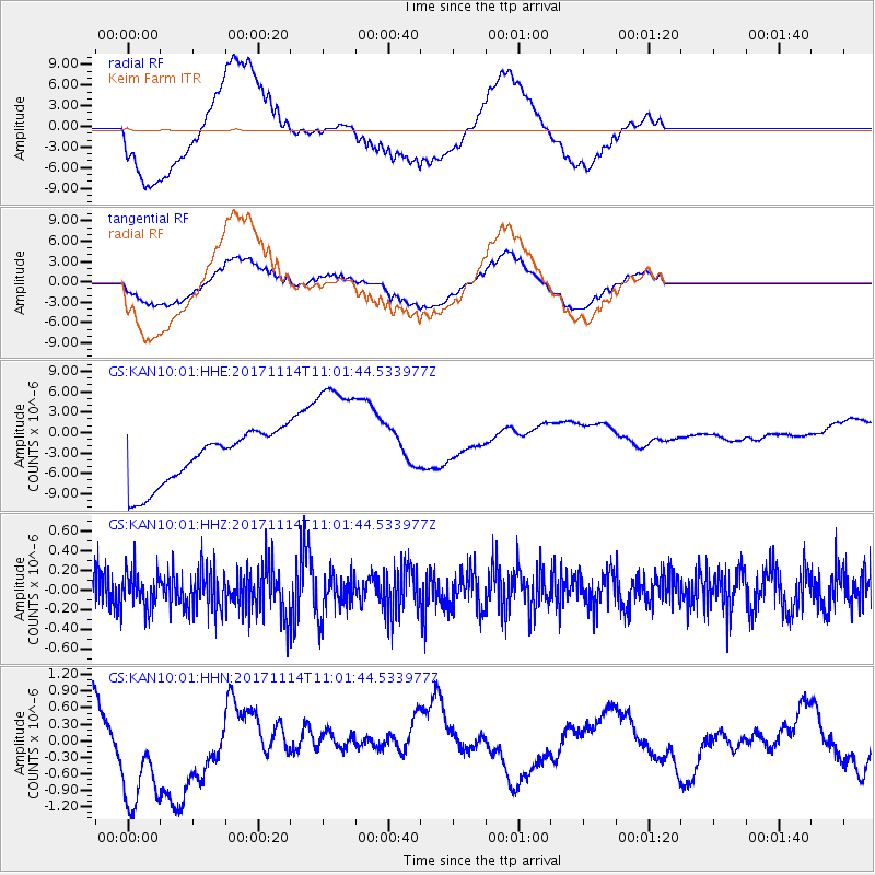
KAN10 Keim Farm - Earthquake Result Viewer
*The percent match for this event was below the threshold and hence no stack was calculated.
| Earthquake location: |
Fiji Islands Region |
| Earthquake latitude/longitude: |
-18.2/-178.0 |
| Earthquake time(UTC): |
2017/11/14 (318) 10:50:05 GMT |
| Earthquake Depth: |
604 km |
| Earthquake Magnitude: |
5.5 Mww |
| Earthquake Catalog/Contributor: |
NEIC PDE/us |
|
| Network: |
GS US Geological Survey Networks |
| Station: |
KAN10 Keim Farm |
| Lat/Lon: |
37.12 N/98.10 W |
| Elevation: |
417 m |
|
| Distance: |
93.0 deg |
| Az: |
51.996 deg |
| Baz: |
249.616 deg |
| Ray Param: |
$rayparam |
*The percent match for this event was below the threshold and hence was not used in the summary stack. |
|
| Radial Match: |
72.73293 % |
| Radial Bump: |
400 |
| Transverse Match: |
69.737175 % |
| Transverse Bump: |
400 |
| SOD ConfigId: |
2429771 |
| Insert Time: |
2017-11-28 10:51:09.825 +0000 |
| GWidth: |
2.5 |
| Max Bumps: |
400 |
| Tol: |
0.001 |
|
Signal To Noise
| Channel | StoN | STA | LTA |
| GS:KAN10:01:HHZ:20171114T11:01:44.533977Z | 1.0498374 | 1.953246E-7 | 1.8605225E-7 |
| GS:KAN10:01:HHN:20171114T11:01:44.533977Z | 2.0273056 | 1.1908201E-6 | 5.873905E-7 |
| GS:KAN10:01:HHE:20171114T11:01:44.533977Z | 2.43709 | 9.479896E-6 | 3.8898424E-6 |
| Arrivals |
| Ps | |
| PpPs | |
| PsPs/PpSs | |


