You are here: Home > Network List > CN - Canadian National Seismograph Network Stations List
> Station NLLB Nanaimo Lost Lake, BC, CA > Earthquake Result Viewer
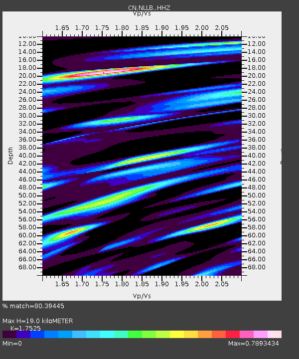
NLLB Nanaimo Lost Lake, BC, CA - Earthquake Result Viewer
| Earthquake location: |
Fiji Islands Region |
| Earthquake latitude/longitude: |
-21.7/-177.1 |
| Earthquake time(UTC): |
2021/04/25 (115) 22:28:00 GMT |
| Earthquake Depth: |
234 km |
| Earthquake Magnitude: |
6.4 Mww |
| Earthquake Catalog/Contributor: |
NEIC PDE/us |
|
| Network: |
CN Canadian National Seismograph Network |
| Station: |
NLLB Nanaimo Lost Lake, BC, CA |
| Lat/Lon: |
49.23 N/123.99 W |
| Elevation: |
199 m |
|
| Distance: |
84.9 deg |
| Az: |
31.747 deg |
| Baz: |
228.287 deg |
| Ray Param: |
0.044580597 |
| Estimated Moho Depth: |
19.0 km |
| Estimated Crust Vp/Vs: |
1.75 |
| Assumed Crust Vp: |
6.566 km/s |
| Estimated Crust Vs: |
3.747 km/s |
| Estimated Crust Poisson's Ratio: |
0.26 |
|
| Radial Match: |
80.39445 % |
| Radial Bump: |
400 |
| Transverse Match: |
58.80411 % |
| Transverse Bump: |
400 |
| SOD ConfigId: |
24334971 |
| Insert Time: |
2021-05-09 22:46:08.606 +0000 |
| GWidth: |
2.5 |
| Max Bumps: |
400 |
| Tol: |
0.001 |
|

Signal To Noise
| Channel | StoN | STA | LTA |
| CN:NLLB: :HHZ:20210425T22:39:37.659986Z | 3.2885299 | 4.962915E-7 | 1.5091591E-7 |
| CN:NLLB: :HHN:20210425T22:39:37.659986Z | 0.9462454 | 1.1215212E-7 | 1.185233E-7 |
| CN:NLLB: :HHE:20210425T22:39:37.659986Z | 1.0904269 | 1.0972608E-7 | 1.0062672E-7 |
| Arrivals |
| Ps | 2.2 SECOND |
| PpPs | 7.8 SECOND |
| PsPs/PpSs | 10.0 SECOND |


