You are here: Home > Network List > IU - Global Seismograph Network (GSN - IRIS/USGS) Stations List
> Station PMG Port Moresby, New Guinea > Earthquake Result Viewer
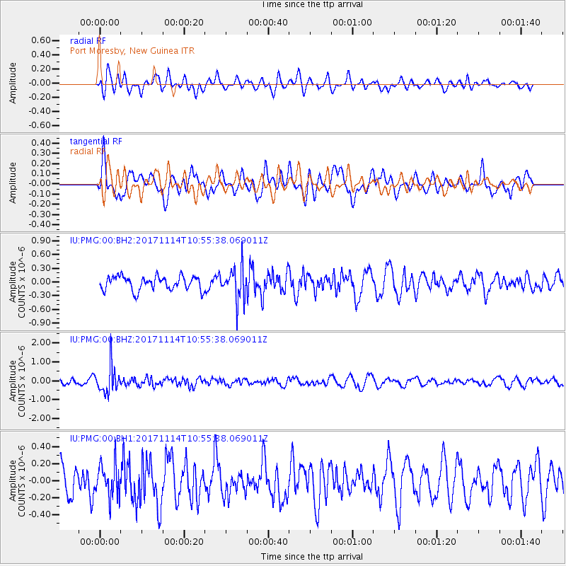
PMG Port Moresby, New Guinea - Earthquake Result Viewer
*The percent match for this event was below the threshold and hence no stack was calculated.
| Earthquake location: |
Fiji Islands Region |
| Earthquake latitude/longitude: |
-18.2/-178.0 |
| Earthquake time(UTC): |
2017/11/14 (318) 10:50:05 GMT |
| Earthquake Depth: |
604 km |
| Earthquake Magnitude: |
5.5 Mww |
| Earthquake Catalog/Contributor: |
NEIC PDE/us |
|
| Network: |
IU Global Seismograph Network (GSN - IRIS/USGS) |
| Station: |
PMG Port Moresby, New Guinea |
| Lat/Lon: |
9.40 S/147.16 E |
| Elevation: |
90 m |
|
| Distance: |
34.9 deg |
| Az: |
279.702 deg |
| Baz: |
108.225 deg |
| Ray Param: |
$rayparam |
*The percent match for this event was below the threshold and hence was not used in the summary stack. |
|
| Radial Match: |
43.599045 % |
| Radial Bump: |
400 |
| Transverse Match: |
55.921658 % |
| Transverse Bump: |
400 |
| SOD ConfigId: |
2429771 |
| Insert Time: |
2017-11-28 10:51:54.250 +0000 |
| GWidth: |
2.5 |
| Max Bumps: |
400 |
| Tol: |
0.001 |
|
Signal To Noise
| Channel | StoN | STA | LTA |
| IU:PMG:00:BHZ:20171114T10:55:38.069011Z | 3.2800908 | 7.2357244E-7 | 2.2059525E-7 |
| IU:PMG:00:BH1:20171114T10:55:38.069011Z | 0.8538196 | 1.9198302E-7 | 2.2485197E-7 |
| IU:PMG:00:BH2:20171114T10:55:38.069011Z | 2.4458315 | 3.6728377E-7 | 1.5016725E-7 |
| Arrivals |
| Ps | |
| PpPs | |
| PsPs/PpSs | |


