You are here: Home > Network List > G - GEOSCOPE Stations List
> Station TAOE Taiohae, Marquises islands > Earthquake Result Viewer
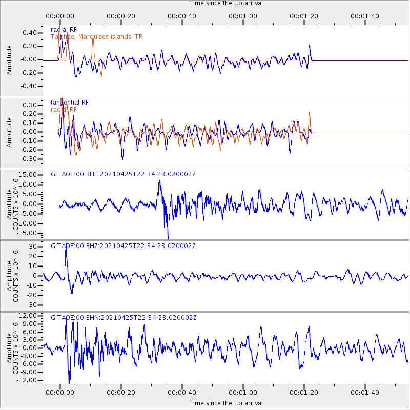
TAOE Taiohae, Marquises islands - Earthquake Result Viewer
*The percent match for this event was below the threshold and hence no stack was calculated.
| Earthquake location: |
Fiji Islands Region |
| Earthquake latitude/longitude: |
-21.7/-177.1 |
| Earthquake time(UTC): |
2021/04/25 (115) 22:28:00 GMT |
| Earthquake Depth: |
234 km |
| Earthquake Magnitude: |
6.4 Mww |
| Earthquake Catalog/Contributor: |
NEIC PDE/us |
|
| Network: |
G GEOSCOPE |
| Station: |
TAOE Taiohae, Marquises islands |
| Lat/Lon: |
8.85 S/140.15 W |
| Elevation: |
800 m |
|
| Distance: |
37.7 deg |
| Az: |
75.997 deg |
| Baz: |
245.948 deg |
| Ray Param: |
$rayparam |
*The percent match for this event was below the threshold and hence was not used in the summary stack. |
|
| Radial Match: |
64.73927 % |
| Radial Bump: |
400 |
| Transverse Match: |
72.093254 % |
| Transverse Bump: |
400 |
| SOD ConfigId: |
24334971 |
| Insert Time: |
2021-05-09 22:47:17.179 +0000 |
| GWidth: |
2.5 |
| Max Bumps: |
400 |
| Tol: |
0.001 |
|
Signal To Noise
| Channel | StoN | STA | LTA |
| G:TAOE:00:BHZ:20210425T22:34:23.020002Z | 7.8165503 | 1.1348003E-5 | 1.4517917E-6 |
| G:TAOE:00:BHN:20210425T22:34:23.020002Z | 5.0146847 | 5.6160893E-6 | 1.1199287E-6 |
| G:TAOE:00:BHE:20210425T22:34:23.020002Z | 3.173446 | 5.0068275E-6 | 1.5777257E-6 |
| Arrivals |
| Ps | |
| PpPs | |
| PsPs/PpSs | |


