You are here: Home > Network List > GS - US Geological Survey Networks Stations List
> Station ASA5 ASA5 > Earthquake Result Viewer
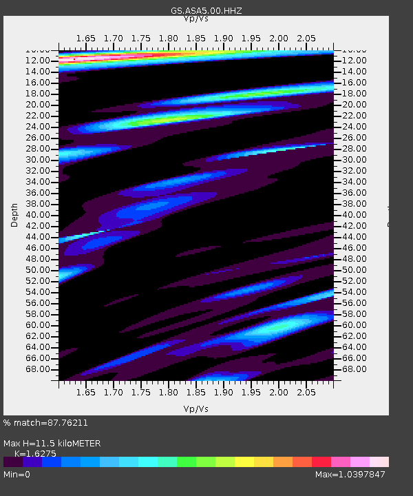
ASA5 ASA5 - Earthquake Result Viewer
| Earthquake location: |
Fiji Islands Region |
| Earthquake latitude/longitude: |
-21.7/-177.1 |
| Earthquake time(UTC): |
2021/04/25 (115) 22:28:00 GMT |
| Earthquake Depth: |
234 km |
| Earthquake Magnitude: |
6.4 Mww |
| Earthquake Catalog/Contributor: |
NEIC PDE/us |
|
| Network: |
GS US Geological Survey Networks |
| Station: |
ASA5 ASA5 |
| Lat/Lon: |
34.94 N/106.46 W |
| Elevation: |
1835 m |
|
| Distance: |
87.5 deg |
| Az: |
50.865 deg |
| Baz: |
241.42 deg |
| Ray Param: |
0.04275041 |
| Estimated Moho Depth: |
11.5 km |
| Estimated Crust Vp/Vs: |
1.63 |
| Assumed Crust Vp: |
6.502 km/s |
| Estimated Crust Vs: |
3.995 km/s |
| Estimated Crust Poisson's Ratio: |
0.20 |
|
| Radial Match: |
87.76211 % |
| Radial Bump: |
400 |
| Transverse Match: |
81.501335 % |
| Transverse Bump: |
323 |
| SOD ConfigId: |
24334971 |
| Insert Time: |
2021-05-09 22:47:56.362 +0000 |
| GWidth: |
2.5 |
| Max Bumps: |
400 |
| Tol: |
0.001 |
|

Signal To Noise
| Channel | StoN | STA | LTA |
| GS:ASA5:00:HHZ:20210425T22:39:50.08003Z | 25.52682 | 1.3780882E-6 | 5.3985897E-8 |
| GS:ASA5:00:HH1:20210425T22:39:50.08003Z | 4.3792224 | 2.4301085E-7 | 5.549178E-8 |
| GS:ASA5:00:HH2:20210425T22:39:50.08003Z | 6.8578153 | 4.2207975E-7 | 6.154726E-8 |
| Arrivals |
| Ps | 1.1 SECOND |
| PpPs | 4.5 SECOND |
| PsPs/PpSs | 5.7 SECOND |


