You are here: Home > Network List > II - Global Seismograph Network (GSN - IRIS/IDA) Stations List
> Station XPFO Pinon Flat, California, USA > Earthquake Result Viewer
XPFO Pinon Flat, California, USA - Earthquake Result Viewer
| Earthquake location: |
Fiji Islands Region |
| Earthquake latitude/longitude: |
-21.7/-177.1 |
| Earthquake time(UTC): |
2021/04/25 (115) 22:28:00 GMT |
| Earthquake Depth: |
234 km |
| Earthquake Magnitude: |
6.4 Mww |
| Earthquake Catalog/Contributor: |
NEIC PDE/us |
|
| Network: |
II Global Seismograph Network (GSN - IRIS/IDA) |
| Station: |
XPFO Pinon Flat, California, USA |
| Lat/Lon: |
33.61 N/116.46 W |
| Elevation: |
1280 m |
|
| Distance: |
79.7 deg |
| Az: |
47.645 deg |
| Baz: |
235.446 deg |
| Ray Param: |
0.04817617 |
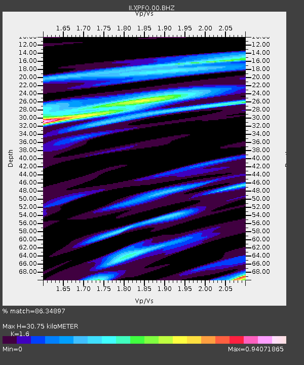
| Estimated Moho Depth: |
30.75 km |
| Estimated Crust Vp/Vs: |
1.60 |
| Assumed Crust Vp: |
6.264 km/s |
| Estimated Crust Vs: |
3.915 km/s |
| Estimated Crust Poisson's Ratio: |
0.18 |
|
| Radial Match: |
86.34897 % |
| Radial Bump: |
384 |
| Transverse Match: |
76.261246 % |
| Transverse Bump: |
400 |
| SOD ConfigId: |
24334971 |
| Insert Time: |
2021-05-09 22:48:51.901 +0000 |
| GWidth: |
2.5 |
| Max Bumps: |
400 |
| Tol: |
0.001 |
|

Signal To Noise
| Channel | StoN | STA | LTA |
| II:XPFO:00:BHZ:20210425T22:39:10.99397Z | 11.569768 | 2.190843E-6 | 1.8935928E-7 |
| II:XPFO:00:BH1:20210425T22:39:10.99397Z | 4.419797 | 5.068122E-7 | 1.14668666E-7 |
| II:XPFO:00:BH2:20210425T22:39:10.99397Z | 10.381581 | 6.5258035E-7 | 6.2859435E-8 |
| Arrivals |
| Ps | 3.0 SECOND |
| PpPs | 12 SECOND |
| PsPs/PpSs | 15 SECOND |


