You are here: Home > Network List > GM - US Geological Survey Networks Stations List
> Station IWM01 Jericho 2M Well Monitoring Station > Earthquake Result Viewer
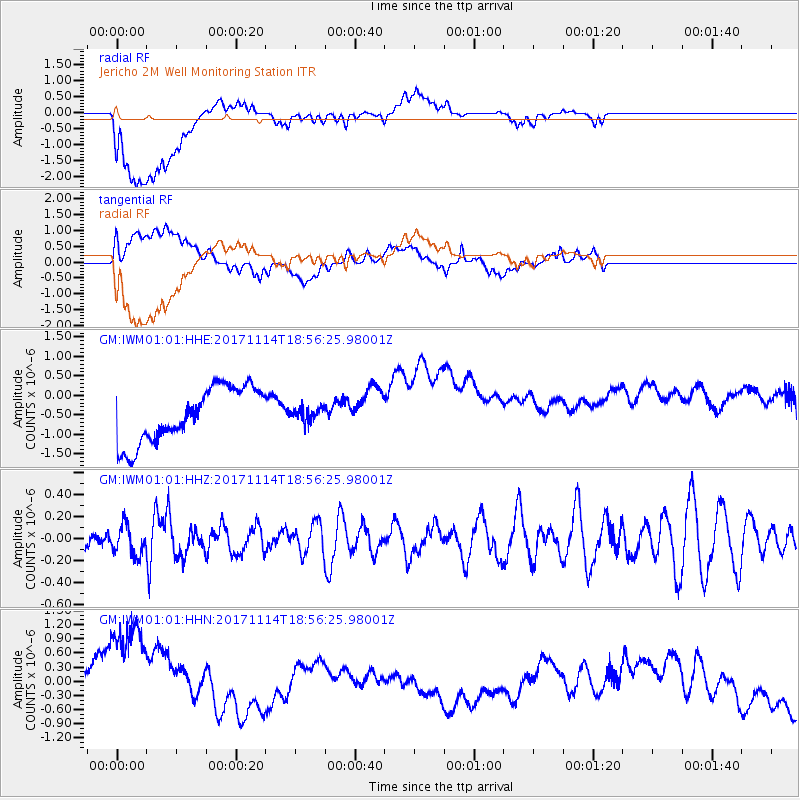
IWM01 Jericho 2M Well Monitoring Station - Earthquake Result Viewer
*The percent match for this event was below the threshold and hence no stack was calculated.
| Earthquake location: |
Tonga Islands Region |
| Earthquake latitude/longitude: |
-18.6/-171.5 |
| Earthquake time(UTC): |
2017/11/14 (318) 18:44:00 GMT |
| Earthquake Depth: |
10 km |
| Earthquake Magnitude: |
5.4 Mww |
| Earthquake Catalog/Contributor: |
NEIC PDE/us |
|
| Network: |
GM US Geological Survey Networks |
| Station: |
IWM01 Jericho 2M Well Monitoring Station |
| Lat/Lon: |
36.73 N/96.53 W |
| Elevation: |
328 m |
|
| Distance: |
89.5 deg |
| Az: |
50.896 deg |
| Baz: |
246.343 deg |
| Ray Param: |
$rayparam |
*The percent match for this event was below the threshold and hence was not used in the summary stack. |
|
| Radial Match: |
26.022402 % |
| Radial Bump: |
400 |
| Transverse Match: |
19.198744 % |
| Transverse Bump: |
400 |
| SOD ConfigId: |
2429771 |
| Insert Time: |
2017-11-28 18:45:03.392 +0000 |
| GWidth: |
2.5 |
| Max Bumps: |
400 |
| Tol: |
0.001 |
|
Signal To Noise
| Channel | StoN | STA | LTA |
| GM:IWM01:01:HHZ:20171114T18:56:25.98001Z | 0.87714314 | 1.3337731E-7 | 1.5205879E-7 |
| GM:IWM01:01:HHN:20171114T18:56:25.98001Z | 2.0401301 | 1.7678694E-6 | 8.665474E-7 |
| GM:IWM01:01:HHE:20171114T18:56:25.98001Z | 0.22883843 | 1.5999265E-7 | 6.9915114E-7 |
| Arrivals |
| Ps | |
| PpPs | |
| PsPs/PpSs | |


