You are here: Home > Network List > NN - Western Great Basin/Eastern Sierra Nevada Stations List
> Station MCA06 Monte Cristo ASL 06 > Earthquake Result Viewer
MCA06 Monte Cristo ASL 06 - Earthquake Result Viewer
| Earthquake location: |
Fiji Islands Region |
| Earthquake latitude/longitude: |
-21.7/-177.1 |
| Earthquake time(UTC): |
2021/04/25 (115) 22:28:00 GMT |
| Earthquake Depth: |
234 km |
| Earthquake Magnitude: |
6.4 Mww |
| Earthquake Catalog/Contributor: |
NEIC PDE/us |
|
| Network: |
NN Western Great Basin/Eastern Sierra Nevada |
| Station: |
MCA06 Monte Cristo ASL 06 |
| Lat/Lon: |
38.01 N/117.88 W |
| Elevation: |
1462 m |
|
| Distance: |
81.3 deg |
| Az: |
43.335 deg |
| Baz: |
233.903 deg |
| Ray Param: |
0.047085565 |
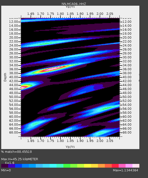
| Estimated Moho Depth: |
45.25 km |
| Estimated Crust Vp/Vs: |
1.60 |
| Assumed Crust Vp: |
6.276 km/s |
| Estimated Crust Vs: |
3.922 km/s |
| Estimated Crust Poisson's Ratio: |
0.18 |
|
| Radial Match: |
88.45518 % |
| Radial Bump: |
382 |
| Transverse Match: |
82.65558 % |
| Transverse Bump: |
306 |
| SOD ConfigId: |
24334971 |
| Insert Time: |
2021-05-09 22:51:13.225 +0000 |
| GWidth: |
2.5 |
| Max Bumps: |
400 |
| Tol: |
0.001 |
|

Signal To Noise
| Channel | StoN | STA | LTA |
| NN:MCA06: :HHZ:20210425T22:39:19.399976Z | 30.189241 | 2.620279E-6 | 8.6795126E-8 |
| NN:MCA06: :HHN:20210425T22:39:19.399976Z | 3.7289562 | 2.88833E-7 | 7.7456804E-8 |
| NN:MCA06: :HHE:20210425T22:39:19.399976Z | 4.9861655 | 7.184142E-7 | 1.440815E-7 |
| Arrivals |
| Ps | 4.4 SECOND |
| PpPs | 18 SECOND |
| PsPs/PpSs | 23 SECOND |


