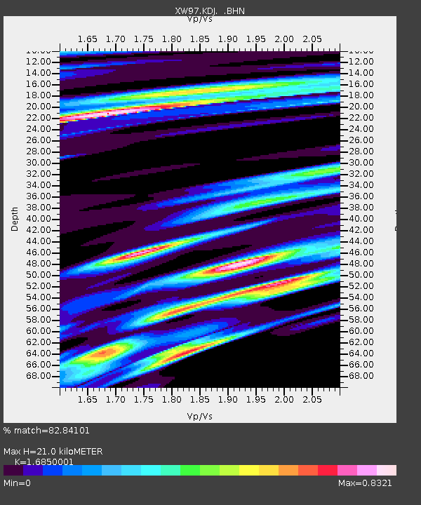
KDJ XW.KDJ - Earthquake Result Viewer
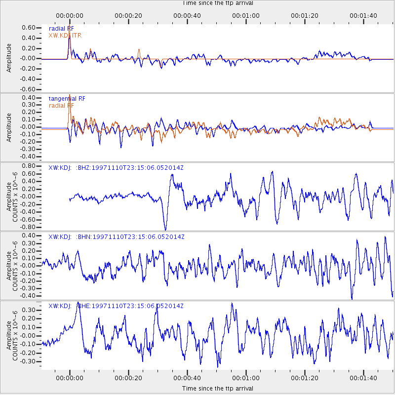
Earthquake location: Southeast Of Honshu, Japan
Earthquake latitude/longitude: 31.2/140.5
Earthquake time(UTC): 1997/11/10 (314) 23:06:44 GMT
Earthquake Depth: 86 km
Earthquake Magnitude: 5.8 MB, 6.1 UNKNOWN, 6.1 MW
Earthquake Catalog/Contributor: WHDF/NEIC
Network: XW Tien Shan Continental Dynamics
Station: KDJ XW.KDJ
Lat/Lon: 42.13 N/77.19 E
Elevation: 1783 m
Distance: 50.9 deg
Az: 301.082 deg
Baz: 80.66 deg
Ray Param: 0.06750248
Estimated Moho Depth: 21.0 km
Estimated Crust Vp/Vs: 1.69
Assumed Crust Vp: 6.306 km/s
Estimated Crust Vs: 3.742 km/s
Estimated Crust Poisson's Ratio: 0.23
Radial Match: 82.84101 %
Radial Bump: 400
Transverse Match: 74.77604 %
Transverse Bump: 400
SOD ConfigId: 6273
Insert Time: 2010-02-26 15:32:11.631 +0000
GWidth: 2.5
Max Bumps: 400
Tol: 0.001

Signal To Noise

ChannelStoNSTALTA
XW:KDJ: :BHN:19971110T23:15:06.052014Z2.10907581.0342651E-74.9038782E-8
XW:KDJ: :BHE:19971110T23:15:06.052014Z3.4654422.180278E-76.2914864E-8
XW:KDJ: :BHZ:19971110T23:15:06.052014Z6.87696464.158601E-76.047146E-8
Arrivals
Ps2.4 SECOND
PpPs8.4 SECOND
PsPs/PpSs11 SECOND