You are here: Home > Network List > SB - UC Santa Barbara Engineering Seismology Network () Stations List
> Station VAFB1 Globe Rd, Vandenberg AFB, CA, USA > Earthquake Result Viewer
VAFB1 Globe Rd, Vandenberg AFB, CA, USA - Earthquake Result Viewer
| Earthquake location: |
Fiji Islands Region |
| Earthquake latitude/longitude: |
-21.7/-177.1 |
| Earthquake time(UTC): |
2021/04/25 (115) 22:28:00 GMT |
| Earthquake Depth: |
234 km |
| Earthquake Magnitude: |
6.4 Mww |
| Earthquake Catalog/Contributor: |
NEIC PDE/us |
|
| Network: |
SB UC Santa Barbara Engineering Seismology Network () |
| Station: |
VAFB1 Globe Rd, Vandenberg AFB, CA, USA |
| Lat/Lon: |
34.86 N/120.60 W |
| Elevation: |
121 m |
|
| Distance: |
77.7 deg |
| Az: |
44.561 deg |
| Baz: |
232.52 deg |
| Ray Param: |
0.04955091 |
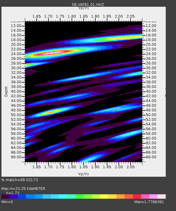
| Estimated Moho Depth: |
23.25 km |
| Estimated Crust Vp/Vs: |
1.72 |
| Assumed Crust Vp: |
6.183 km/s |
| Estimated Crust Vs: |
3.595 km/s |
| Estimated Crust Poisson's Ratio: |
0.24 |
|
| Radial Match: |
89.02173 % |
| Radial Bump: |
400 |
| Transverse Match: |
73.18699 % |
| Transverse Bump: |
400 |
| SOD ConfigId: |
24334971 |
| Insert Time: |
2021-05-09 22:55:48.786 +0000 |
| GWidth: |
2.5 |
| Max Bumps: |
400 |
| Tol: |
0.001 |
|

Signal To Noise
| Channel | StoN | STA | LTA |
| SB:VAFB1:01:HHZ:20210425T22:38:59.904981Z | 13.811384 | 3.235604E-6 | 2.342708E-7 |
| SB:VAFB1:01:HHN:20210425T22:38:59.904981Z | 6.6671333 | 1.0595106E-6 | 1.5891547E-7 |
| SB:VAFB1:01:HHE:20210425T22:38:59.904981Z | 5.4945707 | 1.2252535E-6 | 2.2299349E-7 |
| Arrivals |
| Ps | 2.8 SECOND |
| PpPs | 9.9 SECOND |
| PsPs/PpSs | 13 SECOND |


