You are here: Home > Network List > TA - USArray Transportable Network (new EarthScope stations) Stations List
> Station H31M Peel River, Yukon, CAN > Earthquake Result Viewer
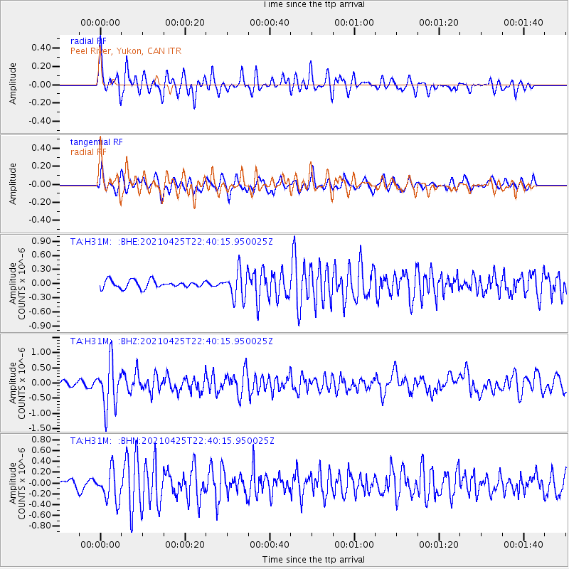
H31M Peel River, Yukon, CAN - Earthquake Result Viewer
*The percent match for this event was below the threshold and hence no stack was calculated.
| Earthquake location: |
Fiji Islands Region |
| Earthquake latitude/longitude: |
-21.7/-177.1 |
| Earthquake time(UTC): |
2021/04/25 (115) 22:28:00 GMT |
| Earthquake Depth: |
234 km |
| Earthquake Magnitude: |
6.4 Mww |
| Earthquake Catalog/Contributor: |
NEIC PDE/us |
|
| Network: |
TA USArray Transportable Network (new EarthScope stations) |
| Station: |
H31M Peel River, Yukon, CAN |
| Lat/Lon: |
65.81 N/134.34 W |
| Elevation: |
642 m |
|
| Distance: |
93.0 deg |
| Az: |
16.26 deg |
| Baz: |
219.189 deg |
| Ray Param: |
$rayparam |
*The percent match for this event was below the threshold and hence was not used in the summary stack. |
|
| Radial Match: |
71.7678 % |
| Radial Bump: |
340 |
| Transverse Match: |
69.47362 % |
| Transverse Bump: |
400 |
| SOD ConfigId: |
24334971 |
| Insert Time: |
2021-05-09 22:56:58.470 +0000 |
| GWidth: |
2.5 |
| Max Bumps: |
400 |
| Tol: |
0.001 |
|
Signal To Noise
| Channel | StoN | STA | LTA |
| TA:H31M: :BHZ:20210425T22:40:15.950025Z | 8.424079 | 7.519236E-7 | 8.9258855E-8 |
| TA:H31M: :BHN:20210425T22:40:15.950025Z | 3.92622 | 2.936051E-7 | 7.47806E-8 |
| TA:H31M: :BHE:20210425T22:40:15.950025Z | 3.7692087 | 3.0715182E-7 | 8.148973E-8 |
| Arrivals |
| Ps | |
| PpPs | |
| PsPs/PpSs | |


