You are here: Home > Network List > TX - Texas Seismological Network Stations List
> Station WTFS Witchita Falls > Earthquake Result Viewer
WTFS Witchita Falls - Earthquake Result Viewer
*The percent match for this event was below the threshold and hence no stack was calculated.
| Earthquake location: |
Fiji Islands Region |
| Earthquake latitude/longitude: |
-21.7/-177.1 |
| Earthquake time(UTC): |
2021/04/25 (115) 22:28:00 GMT |
| Earthquake Depth: |
234 km |
| Earthquake Magnitude: |
6.4 Mww |
| Earthquake Catalog/Contributor: |
NEIC PDE/us |
|
| Network: |
TX Texas Seismological Network |
| Station: |
WTFS Witchita Falls |
| Lat/Lon: |
33.77 N/98.46 W |
| Elevation: |
277 m |
|
| Distance: |
92.9 deg |
| Az: |
54.847 deg |
| Baz: |
245.905 deg |
| Ray Param: |
$rayparam |
*The percent match for this event was below the threshold and hence was not used in the summary stack. |
|
| Radial Match: |
72.22423 % |
| Radial Bump: |
400 |
| Transverse Match: |
59.242905 % |
| Transverse Bump: |
400 |
| SOD ConfigId: |
24334971 |
| Insert Time: |
2021-05-09 23:00:21.241 +0000 |
| GWidth: |
2.5 |
| Max Bumps: |
400 |
| Tol: |
0.001 |
|
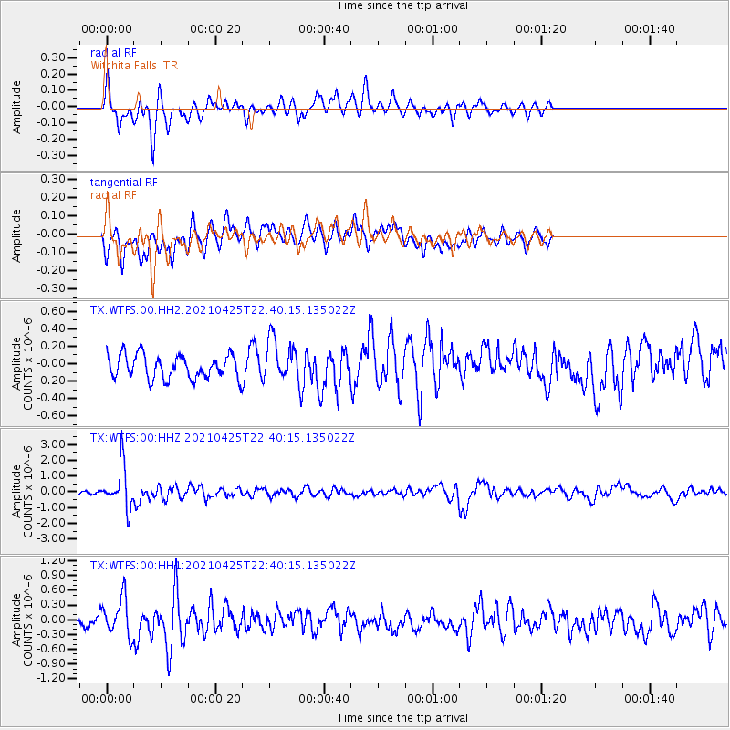
Signal To Noise
| Channel | StoN | STA | LTA |
| TX:WTFS:00:HHZ:20210425T22:40:15.135022Z | 10.28012 | 1.3562819E-6 | 1.319325E-7 |
| TX:WTFS:00:HH1:20210425T22:40:15.135022Z | 2.35594 | 3.7834909E-7 | 1.6059367E-7 |
| TX:WTFS:00:HH2:20210425T22:40:15.135022Z | 1.808739 | 2.4191203E-7 | 1.3374624E-7 |
| Arrivals |
| Ps | |
| PpPs | |
| PsPs/PpSs | |


