You are here: Home > Network List > AV - Alaska Volcano Observatory Stations List
> Station SPCR Ckakachatna River, Mount Spurr, Alaska > Earthquake Result Viewer
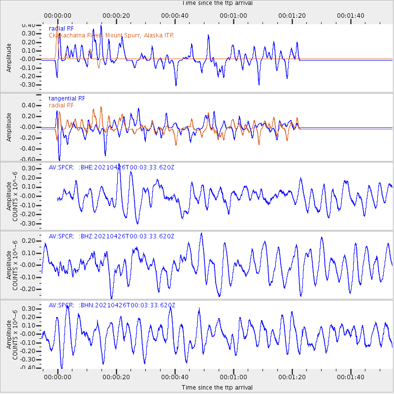
SPCR Ckakachatna River, Mount Spurr, Alaska - Earthquake Result Viewer
*The percent match for this event was below the threshold and hence no stack was calculated.
| Earthquake location: |
Near Coast Of Peru |
| Earthquake latitude/longitude: |
-15.6/-74.6 |
| Earthquake time(UTC): |
2021/04/25 (115) 23:50:30 GMT |
| Earthquake Depth: |
13 km |
| Earthquake Magnitude: |
5.5 mww |
| Earthquake Catalog/Contributor: |
NEIC PDE/us |
|
| Network: |
AV Alaska Volcano Observatory |
| Station: |
SPCR Ckakachatna River, Mount Spurr, Alaska |
| Lat/Lon: |
61.20 N/152.21 W |
| Elevation: |
984 m |
|
| Distance: |
97.7 deg |
| Az: |
331.49 deg |
| Baz: |
108.219 deg |
| Ray Param: |
$rayparam |
*The percent match for this event was below the threshold and hence was not used in the summary stack. |
|
| Radial Match: |
45.02932 % |
| Radial Bump: |
400 |
| Transverse Match: |
54.44503 % |
| Transverse Bump: |
388 |
| SOD ConfigId: |
24334971 |
| Insert Time: |
2021-05-09 23:54:46.491 +0000 |
| GWidth: |
2.5 |
| Max Bumps: |
400 |
| Tol: |
0.001 |
|
Signal To Noise
| Channel | StoN | STA | LTA |
| AV:SPCR: :BHZ:20210426T00:03:33.620Z | 0.3107885 | 3.517581E-8 | 1.13182466E-7 |
| AV:SPCR: :BHN:20210426T00:03:33.620Z | 2.2925127 | 2.257473E-7 | 9.847156E-8 |
| AV:SPCR: :BHE:20210426T00:03:33.620Z | 0.97666293 | 1.0949369E-7 | 1.1211001E-7 |
| Arrivals |
| Ps | |
| PpPs | |
| PsPs/PpSs | |


