You are here: Home > Network List > IW - Intermountain West Stations List
> Station TPAW Teton Pass, Wyoming, USA > Earthquake Result Viewer
TPAW Teton Pass, Wyoming, USA - Earthquake Result Viewer
| Earthquake location: |
Norwegian Sea |
| Earthquake latitude/longitude: |
72.2/0.9 |
| Earthquake time(UTC): |
2009/08/20 (232) 06:35:04 GMT |
| Earthquake Depth: |
6.0 km |
| Earthquake Magnitude: |
5.9 MB, 5.7 MS, 6.0 MW, 6.0 MW |
| Earthquake Catalog/Contributor: |
WHDF/NEIC |
|
| Network: |
IW Intermountain West |
| Station: |
TPAW Teton Pass, Wyoming, USA |
| Lat/Lon: |
43.49 N/110.95 W |
| Elevation: |
2512 m |
|
| Distance: |
55.3 deg |
| Az: |
304.79 deg |
| Baz: |
20.307 deg |
| Ray Param: |
0.064884044 |
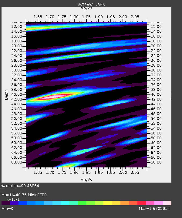
| Estimated Moho Depth: |
40.75 km |
| Estimated Crust Vp/Vs: |
1.71 |
| Assumed Crust Vp: |
6.207 km/s |
| Estimated Crust Vs: |
3.63 km/s |
| Estimated Crust Poisson's Ratio: |
0.24 |
|
| Radial Match: |
90.46864 % |
| Radial Bump: |
400 |
| Transverse Match: |
80.66078 % |
| Transverse Bump: |
400 |
| SOD ConfigId: |
2622 |
| Insert Time: |
2010-03-09 07:39:41.263 +0000 |
| GWidth: |
2.5 |
| Max Bumps: |
400 |
| Tol: |
0.001 |
|

Signal To Noise
| Channel | StoN | STA | LTA |
| IW:TPAW: :BHN:20090820T06:44:07.705024Z | 9.704119 | 5.5942013E-7 | 5.7647703E-8 |
| IW:TPAW: :BHE:20090820T06:44:07.705024Z | 4.069941 | 2.2027118E-7 | 5.4121465E-8 |
| IW:TPAW: :BHZ:20090820T06:44:07.705024Z | 2.7527356 | 1.7077492E-7 | 6.2038254E-8 |
| Arrivals |
| Ps | 4.9 SECOND |
| PpPs | 17 SECOND |
| PsPs/PpSs | 22 SECOND |


