You are here: Home > Network List > IW - Intermountain West Stations List
> Station TPAW Teton Pass, Wyoming, USA > Earthquake Result Viewer
TPAW Teton Pass, Wyoming, USA - Earthquake Result Viewer
| Earthquake location: |
Off Coast Of Ecuador |
| Earthquake latitude/longitude: |
1.4/-85.2 |
| Earthquake time(UTC): |
2009/05/10 (130) 01:16:06 GMT |
| Earthquake Depth: |
6.0 km |
| Earthquake Magnitude: |
5.5 MB, 5.7 MS, 6.1 MW, 6.1 MW |
| Earthquake Catalog/Contributor: |
WHDF/NEIC |
|
| Network: |
IW Intermountain West |
| Station: |
TPAW Teton Pass, Wyoming, USA |
| Lat/Lon: |
43.49 N/110.95 W |
| Elevation: |
2512 m |
|
| Distance: |
47.8 deg |
| Az: |
334.703 deg |
| Baz: |
144.059 deg |
| Ray Param: |
0.06977043 |
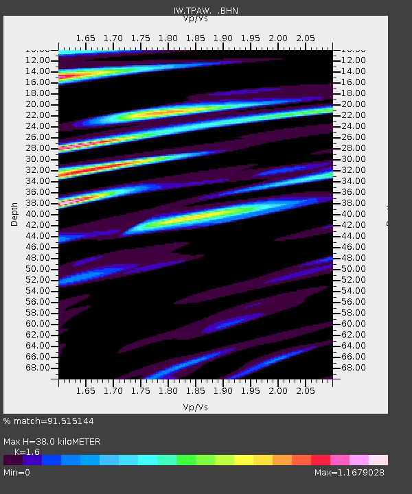
| Estimated Moho Depth: |
38.0 km |
| Estimated Crust Vp/Vs: |
1.60 |
| Assumed Crust Vp: |
6.207 km/s |
| Estimated Crust Vs: |
3.879 km/s |
| Estimated Crust Poisson's Ratio: |
0.18 |
|
| Radial Match: |
91.515144 % |
| Radial Bump: |
400 |
| Transverse Match: |
81.904045 % |
| Transverse Bump: |
400 |
| SOD ConfigId: |
2658 |
| Insert Time: |
2010-03-09 07:40:12.768 +0000 |
| GWidth: |
2.5 |
| Max Bumps: |
400 |
| Tol: |
0.001 |
|

Signal To Noise
| Channel | StoN | STA | LTA |
| IW:TPAW: :BHN:20090510T01:24:14.113992Z | 5.9881763 | 3.6465474E-7 | 6.089579E-8 |
| IW:TPAW: :BHE:20090510T01:24:14.113992Z | 2.3009758 | 1.7462168E-7 | 7.589027E-8 |
| IW:TPAW: :BHZ:20090510T01:24:14.113992Z | 1.394358 | 1.4294956E-7 | 1.02519984E-7 |
| Arrivals |
| Ps | 3.9 SECOND |
| PpPs | 15 SECOND |
| PsPs/PpSs | 19 SECOND |


