You are here: Home > Network List > PF - Volcanologic Network of Piton de Fournaise-OVPF Stations List
> Station HIM cratere Himiltrude > Earthquake Result Viewer
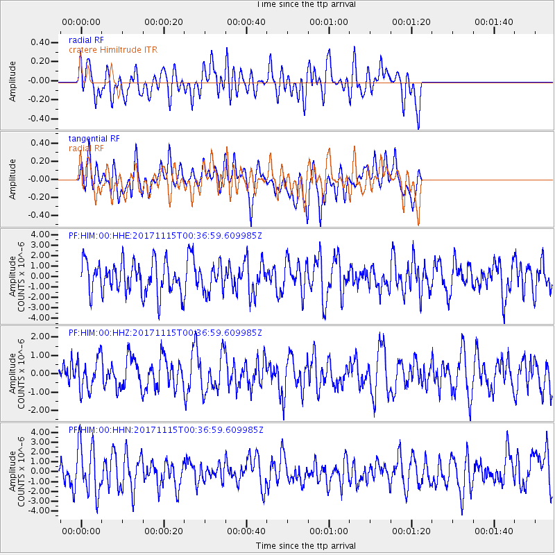
HIM cratere Himiltrude - Earthquake Result Viewer
*The percent match for this event was below the threshold and hence no stack was calculated.
| Earthquake location: |
South Of Mariana Islands |
| Earthquake latitude/longitude: |
13.1/143.7 |
| Earthquake time(UTC): |
2017/11/15 (319) 00:24:32 GMT |
| Earthquake Depth: |
123 km |
| Earthquake Magnitude: |
5.8 Mww |
| Earthquake Catalog/Contributor: |
NEIC PDE/us |
|
| Network: |
PF Volcanologic Network of Piton de Fournaise-OVPF |
| Station: |
HIM cratere Himiltrude |
| Lat/Lon: |
21.21 S/55.72 E |
| Elevation: |
1958 m |
|
| Distance: |
92.8 deg |
| Az: |
248.995 deg |
| Baz: |
77.144 deg |
| Ray Param: |
$rayparam |
*The percent match for this event was below the threshold and hence was not used in the summary stack. |
|
| Radial Match: |
40.49409 % |
| Radial Bump: |
400 |
| Transverse Match: |
42.310154 % |
| Transverse Bump: |
400 |
| SOD ConfigId: |
2429771 |
| Insert Time: |
2017-11-29 00:27:07.253 +0000 |
| GWidth: |
2.5 |
| Max Bumps: |
400 |
| Tol: |
0.001 |
|
Signal To Noise
| Channel | StoN | STA | LTA |
| PF:HIM:00:HHZ:20171115T00:36:59.609985Z | 1.1788132 | 8.8756383E-7 | 7.5292996E-7 |
| PF:HIM:00:HHN:20171115T00:36:59.609985Z | 1.8860526 | 2.5712682E-6 | 1.3633066E-6 |
| PF:HIM:00:HHE:20171115T00:36:59.609985Z | 0.8498899 | 1.266986E-6 | 1.4907649E-6 |
| Arrivals |
| Ps | |
| PpPs | |
| PsPs/PpSs | |


