You are here: Home > Network List > TA - USArray Transportable Network (new EarthScope stations) Stations List
> Station TOLK Toolik Lake Research Station, AK, USA > Earthquake Result Viewer
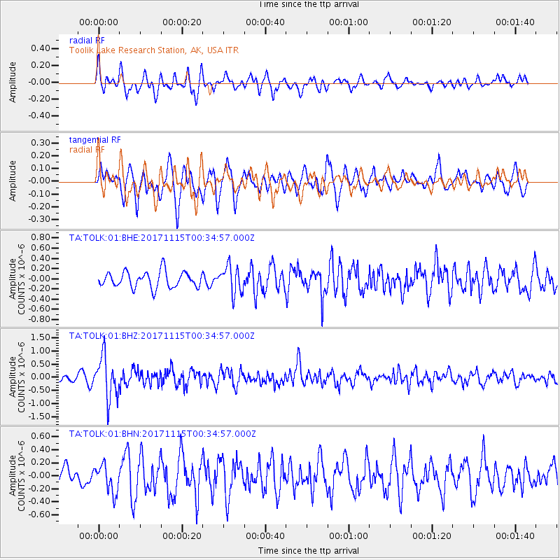
TOLK Toolik Lake Research Station, AK, USA - Earthquake Result Viewer
*The percent match for this event was below the threshold and hence no stack was calculated.
| Earthquake location: |
South Of Mariana Islands |
| Earthquake latitude/longitude: |
13.1/143.7 |
| Earthquake time(UTC): |
2017/11/15 (319) 00:24:32 GMT |
| Earthquake Depth: |
123 km |
| Earthquake Magnitude: |
5.8 Mww |
| Earthquake Catalog/Contributor: |
NEIC PDE/us |
|
| Network: |
TA USArray Transportable Network (new EarthScope stations) |
| Station: |
TOLK Toolik Lake Research Station, AK, USA |
| Lat/Lon: |
68.64 N/149.57 W |
| Elevation: |
760 m |
|
| Distance: |
69.5 deg |
| Az: |
21.06 deg |
| Baz: |
252.906 deg |
| Ray Param: |
$rayparam |
*The percent match for this event was below the threshold and hence was not used in the summary stack. |
|
| Radial Match: |
63.16682 % |
| Radial Bump: |
400 |
| Transverse Match: |
64.253426 % |
| Transverse Bump: |
400 |
| SOD ConfigId: |
2429771 |
| Insert Time: |
2017-11-29 00:27:19.068 +0000 |
| GWidth: |
2.5 |
| Max Bumps: |
400 |
| Tol: |
0.001 |
|
Signal To Noise
| Channel | StoN | STA | LTA |
| TA:TOLK:01:BHZ:20171115T00:34:57.000Z | 6.85236 | 8.1027537E-7 | 1.1824764E-7 |
| TA:TOLK:01:BHN:20171115T00:34:57.000Z | 1.1637355 | 2.1757634E-7 | 1.8696373E-7 |
| TA:TOLK:01:BHE:20171115T00:34:57.000Z | 1.7405182 | 2.726806E-7 | 1.5666635E-7 |
| Arrivals |
| Ps | |
| PpPs | |
| PsPs/PpSs | |


