You are here: Home > Network List > AK - Alaska Regional Network Stations List
> Station CUT Chulitna, AK, USA > Earthquake Result Viewer
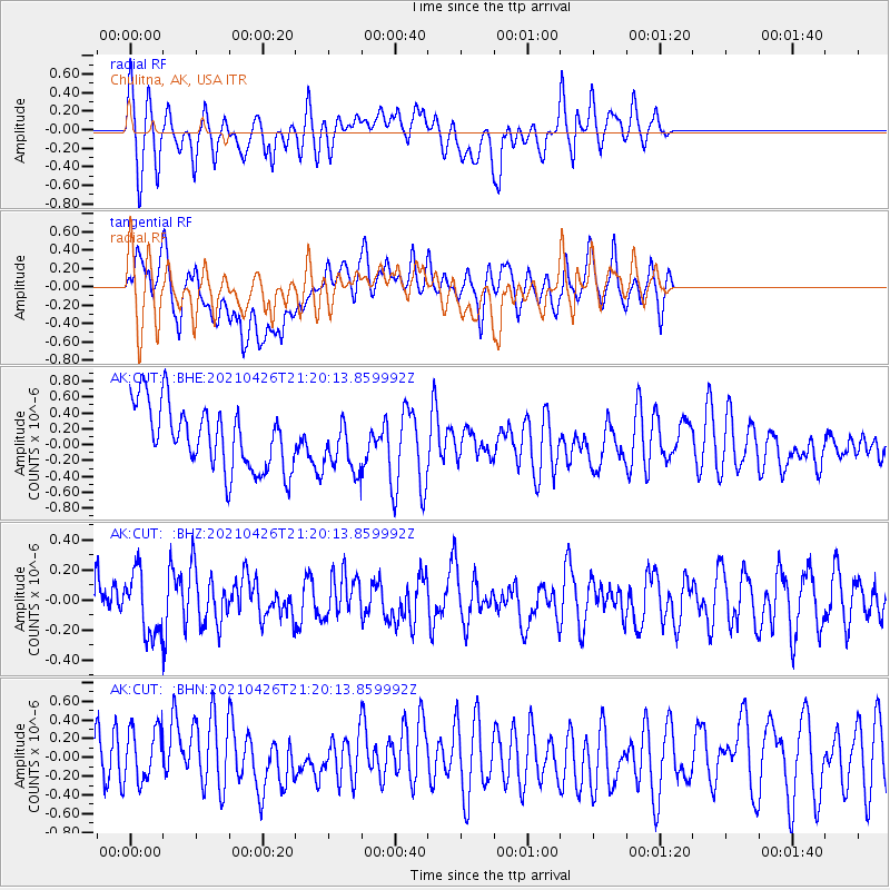
CUT Chulitna, AK, USA - Earthquake Result Viewer
*The percent match for this event was below the threshold and hence no stack was calculated.
| Earthquake location: |
Kermadec Islands Region |
| Earthquake latitude/longitude: |
-29.3/-176.7 |
| Earthquake time(UTC): |
2021/04/26 (116) 21:07:28 GMT |
| Earthquake Depth: |
10 km |
| Earthquake Magnitude: |
5.8 mww |
| Earthquake Catalog/Contributor: |
NEIC PDE/us |
|
| Network: |
AK Alaska Regional Network |
| Station: |
CUT Chulitna, AK, USA |
| Lat/Lon: |
62.41 N/150.26 W |
| Elevation: |
574 m |
|
| Distance: |
93.8 deg |
| Az: |
11.99 deg |
| Baz: |
202.941 deg |
| Ray Param: |
$rayparam |
*The percent match for this event was below the threshold and hence was not used in the summary stack. |
|
| Radial Match: |
64.04396 % |
| Radial Bump: |
400 |
| Transverse Match: |
59.154293 % |
| Transverse Bump: |
400 |
| SOD ConfigId: |
24334971 |
| Insert Time: |
2021-05-10 21:11:04.535 +0000 |
| GWidth: |
2.5 |
| Max Bumps: |
400 |
| Tol: |
0.001 |
|
Signal To Noise
| Channel | StoN | STA | LTA |
| AK:CUT: :BHZ:20210426T21:20:13.859992Z | 1.2020155 | 2.0800373E-7 | 1.7304578E-7 |
| AK:CUT: :BHN:20210426T21:20:13.859992Z | 1.2028738 | 3.1019292E-7 | 2.5787654E-7 |
| AK:CUT: :BHE:20210426T21:20:13.859992Z | 0.80181485 | 3.274745E-7 | 4.0841664E-7 |
| Arrivals |
| Ps | |
| PpPs | |
| PsPs/PpSs | |


