You are here: Home > Network List > AV - Alaska Volcano Observatory Stations List
> Station MAPS Pakushin Southeast, Makushin Volcano, Alaska > Earthquake Result Viewer
MAPS Pakushin Southeast, Makushin Volcano, Alaska - Earthquake Result Viewer
| Earthquake location: |
Kermadec Islands Region |
| Earthquake latitude/longitude: |
-29.3/-176.7 |
| Earthquake time(UTC): |
2021/04/26 (116) 21:07:28 GMT |
| Earthquake Depth: |
10 km |
| Earthquake Magnitude: |
5.8 mww |
| Earthquake Catalog/Contributor: |
NEIC PDE/us |
|
| Network: |
AV Alaska Volcano Observatory |
| Station: |
MAPS Pakushin Southeast, Makushin Volcano, Alaska |
| Lat/Lon: |
53.81 N/166.94 W |
| Elevation: |
333 m |
|
| Distance: |
83.2 deg |
| Az: |
5.809 deg |
| Baz: |
188.574 deg |
| Ray Param: |
0.046380296 |
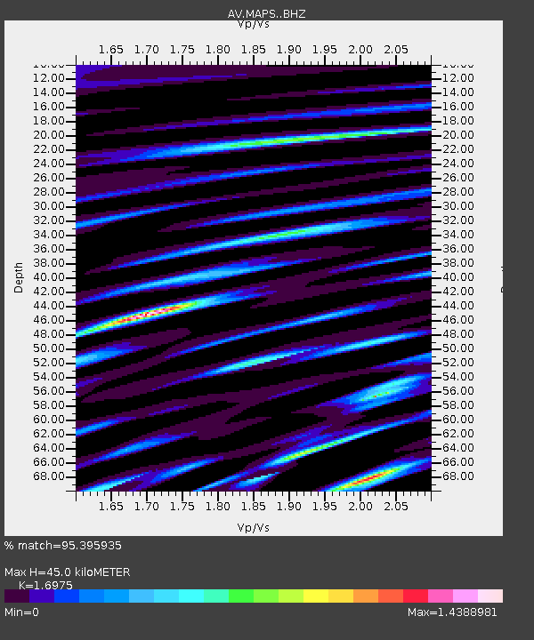
| Estimated Moho Depth: |
45.0 km |
| Estimated Crust Vp/Vs: |
1.70 |
| Assumed Crust Vp: |
3.943 km/s |
| Estimated Crust Vs: |
2.323 km/s |
| Estimated Crust Poisson's Ratio: |
0.23 |
|
| Radial Match: |
95.395935 % |
| Radial Bump: |
256 |
| Transverse Match: |
92.379425 % |
| Transverse Bump: |
329 |
| SOD ConfigId: |
24334971 |
| Insert Time: |
2021-05-10 21:13:05.716 +0000 |
| GWidth: |
2.5 |
| Max Bumps: |
400 |
| Tol: |
0.001 |
|

Signal To Noise
| Channel | StoN | STA | LTA |
| AV:MAPS: :BHZ:20210426T21:19:23.039984Z | 0.8727682 | 4.1177987E-7 | 4.71809E-7 |
| AV:MAPS: :BHN:20210426T21:19:23.039984Z | 0.76586473 | 9.92702E-7 | 1.2961845E-6 |
| AV:MAPS: :BHE:20210426T21:19:23.039984Z | 0.69700795 | 3.263194E-7 | 4.6817172E-7 |
| Arrivals |
| Ps | 8.0 SECOND |
| PpPs | 30 SECOND |
| PsPs/PpSs | 39 SECOND |


