You are here: Home > Network List > US - United States National Seismic Network Stations List
> Station HAWA Hanford, Washington, USA > Earthquake Result Viewer
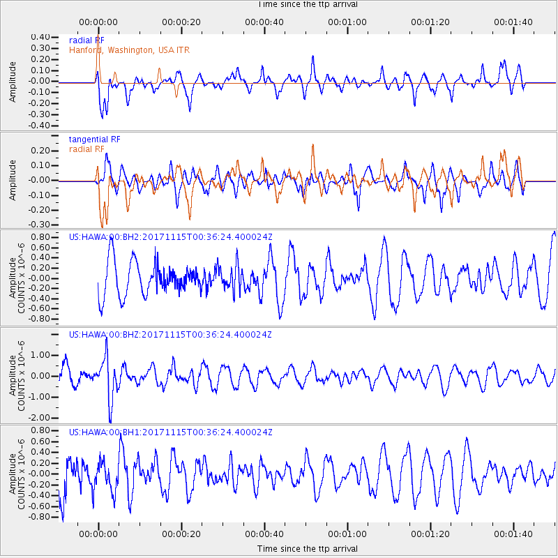
HAWA Hanford, Washington, USA - Earthquake Result Viewer
*The percent match for this event was below the threshold and hence no stack was calculated.
| Earthquake location: |
South Of Mariana Islands |
| Earthquake latitude/longitude: |
13.1/143.7 |
| Earthquake time(UTC): |
2017/11/15 (319) 00:24:32 GMT |
| Earthquake Depth: |
123 km |
| Earthquake Magnitude: |
5.8 Mww |
| Earthquake Catalog/Contributor: |
NEIC PDE/us |
|
| Network: |
US United States National Seismic Network |
| Station: |
HAWA Hanford, Washington, USA |
| Lat/Lon: |
46.39 N/119.53 W |
| Elevation: |
364 m |
|
| Distance: |
85.3 deg |
| Az: |
43.598 deg |
| Baz: |
283.868 deg |
| Ray Param: |
$rayparam |
*The percent match for this event was below the threshold and hence was not used in the summary stack. |
|
| Radial Match: |
74.07068 % |
| Radial Bump: |
400 |
| Transverse Match: |
60.789555 % |
| Transverse Bump: |
400 |
| SOD ConfigId: |
2429771 |
| Insert Time: |
2017-11-29 00:27:32.987 +0000 |
| GWidth: |
2.5 |
| Max Bumps: |
400 |
| Tol: |
0.001 |
|
Signal To Noise
| Channel | StoN | STA | LTA |
| US:HAWA:00:BHZ:20171115T00:36:24.400024Z | 2.7580082 | 9.948133E-7 | 3.606999E-7 |
| US:HAWA:00:BH1:20171115T00:36:24.400024Z | 0.63379806 | 2.5200868E-7 | 3.9761667E-7 |
| US:HAWA:00:BH2:20171115T00:36:24.400024Z | 0.7118075 | 2.2924557E-7 | 3.220612E-7 |
| Arrivals |
| Ps | |
| PpPs | |
| PsPs/PpSs | |


