You are here: Home > Network List > CI - Caltech Regional Seismic Network Stations List
> Station BAR Barrett, Tecate, CA, USA > Earthquake Result Viewer
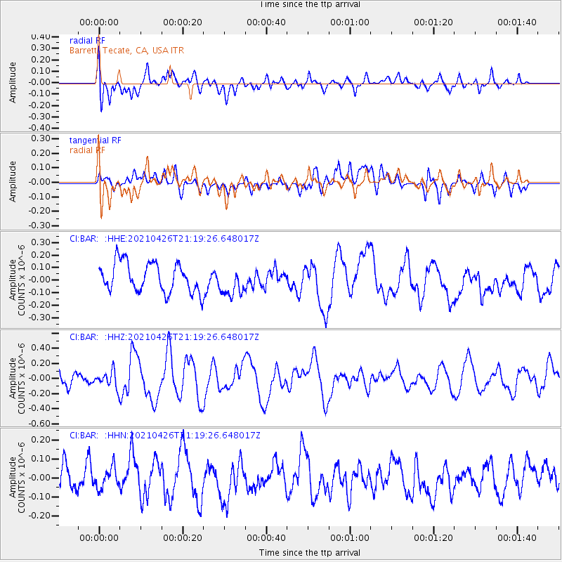
BAR Barrett, Tecate, CA, USA - Earthquake Result Viewer
*The percent match for this event was below the threshold and hence no stack was calculated.
| Earthquake location: |
Kermadec Islands Region |
| Earthquake latitude/longitude: |
-29.3/-176.7 |
| Earthquake time(UTC): |
2021/04/26 (116) 21:07:28 GMT |
| Earthquake Depth: |
10 km |
| Earthquake Magnitude: |
5.8 mww |
| Earthquake Catalog/Contributor: |
NEIC PDE/us |
|
| Network: |
CI Caltech Regional Seismic Network |
| Station: |
BAR Barrett, Tecate, CA, USA |
| Lat/Lon: |
32.68 N/116.67 W |
| Elevation: |
521 m |
|
| Distance: |
83.9 deg |
| Az: |
47.284 deg |
| Baz: |
229.565 deg |
| Ray Param: |
$rayparam |
*The percent match for this event was below the threshold and hence was not used in the summary stack. |
|
| Radial Match: |
49.539783 % |
| Radial Bump: |
400 |
| Transverse Match: |
43.948677 % |
| Transverse Bump: |
400 |
| SOD ConfigId: |
24334971 |
| Insert Time: |
2021-05-10 21:15:16.985 +0000 |
| GWidth: |
2.5 |
| Max Bumps: |
400 |
| Tol: |
0.001 |
|
Signal To Noise
| Channel | StoN | STA | LTA |
| CI:BAR: :HHZ:20210426T21:19:26.648017Z | 0.8608236 | 1.11922375E-7 | 1.3001778E-7 |
| CI:BAR: :HHN:20210426T21:19:26.648017Z | 0.76269186 | 5.6039905E-8 | 7.347647E-8 |
| CI:BAR: :HHE:20210426T21:19:26.648017Z | 1.0226878 | 1.1903173E-7 | 1.1639107E-7 |
| Arrivals |
| Ps | |
| PpPs | |
| PsPs/PpSs | |


