You are here: Home > Network List > US - United States National Seismic Network Stations List
> Station MSO Missoula, Montana, USA > Earthquake Result Viewer
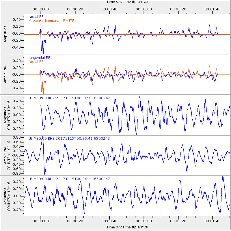
MSO Missoula, Montana, USA - Earthquake Result Viewer
*The percent match for this event was below the threshold and hence no stack was calculated.
| Earthquake location: |
South Of Mariana Islands |
| Earthquake latitude/longitude: |
13.1/143.7 |
| Earthquake time(UTC): |
2017/11/15 (319) 00:24:32 GMT |
| Earthquake Depth: |
123 km |
| Earthquake Magnitude: |
5.8 Mww |
| Earthquake Catalog/Contributor: |
NEIC PDE/us |
|
| Network: |
US United States National Seismic Network |
| Station: |
MSO Missoula, Montana, USA |
| Lat/Lon: |
46.83 N/113.94 W |
| Elevation: |
1264 m |
|
| Distance: |
88.9 deg |
| Az: |
42.124 deg |
| Baz: |
287.845 deg |
| Ray Param: |
$rayparam |
*The percent match for this event was below the threshold and hence was not used in the summary stack. |
|
| Radial Match: |
71.09774 % |
| Radial Bump: |
400 |
| Transverse Match: |
46.821438 % |
| Transverse Bump: |
400 |
| SOD ConfigId: |
2429771 |
| Insert Time: |
2017-11-29 00:27:41.488 +0000 |
| GWidth: |
2.5 |
| Max Bumps: |
400 |
| Tol: |
0.001 |
|
Signal To Noise
| Channel | StoN | STA | LTA |
| US:MSO:00:BHZ:20171115T00:36:41.650024Z | 2.670476 | 4.7601858E-7 | 1.7825234E-7 |
| US:MSO:00:BH1:20171115T00:36:41.650024Z | 1.057657 | 1.4973494E-7 | 1.415723E-7 |
| US:MSO:00:BH2:20171115T00:36:41.650024Z | 0.9292163 | 1.8297982E-7 | 1.9691842E-7 |
| Arrivals |
| Ps | |
| PpPs | |
| PsPs/PpSs | |


