You are here: Home > Network List > US - United States National Seismic Network Stations List
> Station TPNV Topopah Spring, Nevada, USA > Earthquake Result Viewer
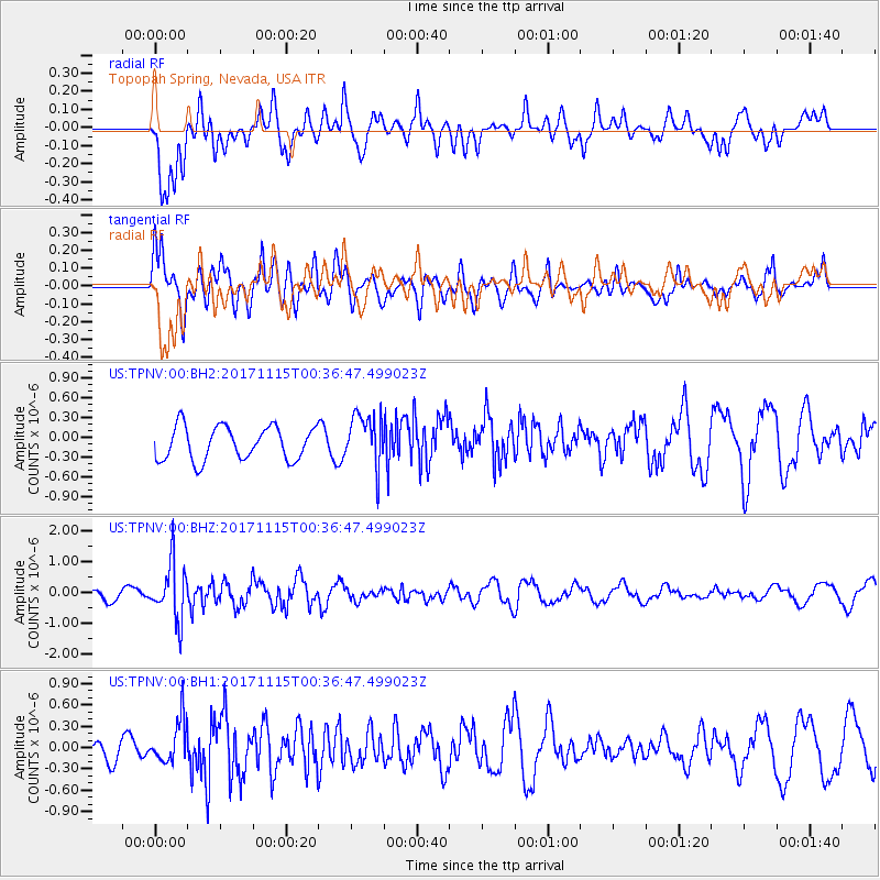
TPNV Topopah Spring, Nevada, USA - Earthquake Result Viewer
*The percent match for this event was below the threshold and hence no stack was calculated.
| Earthquake location: |
South Of Mariana Islands |
| Earthquake latitude/longitude: |
13.1/143.7 |
| Earthquake time(UTC): |
2017/11/15 (319) 00:24:32 GMT |
| Earthquake Depth: |
123 km |
| Earthquake Magnitude: |
5.8 Mww |
| Earthquake Catalog/Contributor: |
NEIC PDE/us |
|
| Network: |
US United States National Seismic Network |
| Station: |
TPNV Topopah Spring, Nevada, USA |
| Lat/Lon: |
36.95 N/116.25 W |
| Elevation: |
1600 m |
|
| Distance: |
90.1 deg |
| Az: |
52.066 deg |
| Baz: |
286.39 deg |
| Ray Param: |
$rayparam |
*The percent match for this event was below the threshold and hence was not used in the summary stack. |
|
| Radial Match: |
67.483864 % |
| Radial Bump: |
400 |
| Transverse Match: |
65.50118 % |
| Transverse Bump: |
400 |
| SOD ConfigId: |
2429771 |
| Insert Time: |
2017-11-29 00:27:47.472 +0000 |
| GWidth: |
2.5 |
| Max Bumps: |
400 |
| Tol: |
0.001 |
|
Signal To Noise
| Channel | StoN | STA | LTA |
| US:TPNV:00:BHZ:20171115T00:36:47.499023Z | 4.176714 | 9.001731E-7 | 2.1552185E-7 |
| US:TPNV:00:BH1:20171115T00:36:47.499023Z | 2.3750508 | 2.9935094E-7 | 1.2603981E-7 |
| US:TPNV:00:BH2:20171115T00:36:47.499023Z | 1.5865608 | 3.9901184E-7 | 2.514948E-7 |
| Arrivals |
| Ps | |
| PpPs | |
| PsPs/PpSs | |


