You are here: Home > Network List > AV - Alaska Volcano Observatory Stations List
> Station MAPS Pakushin Southeast, Makushin Volcano, Alaska > Earthquake Result Viewer
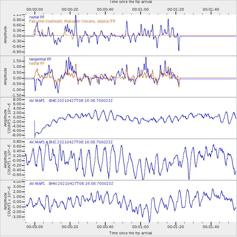
MAPS Pakushin Southeast, Makushin Volcano, Alaska - Earthquake Result Viewer
*The percent match for this event was below the threshold and hence no stack was calculated.
| Earthquake location: |
Near N Coast Of New Guinea, P.N.G. |
| Earthquake latitude/longitude: |
-3.4/145.5 |
| Earthquake time(UTC): |
2021/04/27 (117) 08:05:31 GMT |
| Earthquake Depth: |
10 km |
| Earthquake Magnitude: |
5.9 mww |
| Earthquake Catalog/Contributor: |
NEIC PDE/us |
|
| Network: |
AV Alaska Volcano Observatory |
| Station: |
MAPS Pakushin Southeast, Makushin Volcano, Alaska |
| Lat/Lon: |
53.81 N/166.94 W |
| Elevation: |
333 m |
|
| Distance: |
69.4 deg |
| Az: |
27.881 deg |
| Baz: |
231.917 deg |
| Ray Param: |
$rayparam |
*The percent match for this event was below the threshold and hence was not used in the summary stack. |
|
| Radial Match: |
61.91022 % |
| Radial Bump: |
327 |
| Transverse Match: |
57.963535 % |
| Transverse Bump: |
352 |
| SOD ConfigId: |
24334971 |
| Insert Time: |
2021-05-11 08:10:58.367 +0000 |
| GWidth: |
2.5 |
| Max Bumps: |
400 |
| Tol: |
0.001 |
|
Signal To Noise
| Channel | StoN | STA | LTA |
| AV:MAPS: :BHZ:20210427T08:16:08.700023Z | 1.6109188 | 5.190544E-7 | 3.2221018E-7 |
| AV:MAPS: :BHN:20210427T08:16:08.700023Z | 0.67584753 | 1.1045003E-6 | 1.6342448E-6 |
| AV:MAPS: :BHE:20210427T08:16:08.700023Z | 1.2615658 | 3.5650678E-6 | 2.8259071E-6 |
| Arrivals |
| Ps | |
| PpPs | |
| PsPs/PpSs | |


