You are here: Home > Network List > CI - Caltech Regional Seismic Network Stations List
> Station MPM Manuel Prospect Mine, California, USA > Earthquake Result Viewer
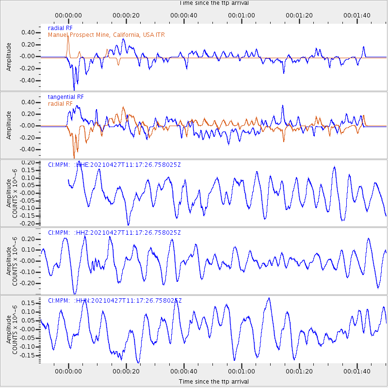
MPM Manuel Prospect Mine, California, USA - Earthquake Result Viewer
*The percent match for this event was below the threshold and hence no stack was calculated.
| Earthquake location: |
Near N Coast Of New Guinea, P.N.G. |
| Earthquake latitude/longitude: |
-3.4/145.7 |
| Earthquake time(UTC): |
2021/04/27 (117) 11:04:24 GMT |
| Earthquake Depth: |
10 km |
| Earthquake Magnitude: |
5.5 mww |
| Earthquake Catalog/Contributor: |
NEIC PDE/us |
|
| Network: |
CI Caltech Regional Seismic Network |
| Station: |
MPM Manuel Prospect Mine, California, USA |
| Lat/Lon: |
36.06 N/117.49 W |
| Elevation: |
185 m |
|
| Distance: |
97.5 deg |
| Az: |
54.243 deg |
| Baz: |
271.268 deg |
| Ray Param: |
$rayparam |
*The percent match for this event was below the threshold and hence was not used in the summary stack. |
|
| Radial Match: |
46.34919 % |
| Radial Bump: |
400 |
| Transverse Match: |
56.725136 % |
| Transverse Bump: |
400 |
| SOD ConfigId: |
24334971 |
| Insert Time: |
2021-05-11 11:10:12.709 +0000 |
| GWidth: |
2.5 |
| Max Bumps: |
400 |
| Tol: |
0.001 |
|
Signal To Noise
| Channel | StoN | STA | LTA |
| CI:MPM: :HHZ:20210427T11:17:26.758025Z | 2.7375076 | 1.7631773E-7 | 6.440812E-8 |
| CI:MPM: :HHN:20210427T11:17:26.758025Z | 1.0372032 | 7.23634E-8 | 6.9767815E-8 |
| CI:MPM: :HHE:20210427T11:17:26.758025Z | 0.7139162 | 6.344753E-8 | 8.8872525E-8 |
| Arrivals |
| Ps | |
| PpPs | |
| PsPs/PpSs | |


