You are here: Home > Network List > TA - USArray Transportable Network (new EarthScope stations) Stations List
> Station D23K Nanushuk River, AK USA > Earthquake Result Viewer
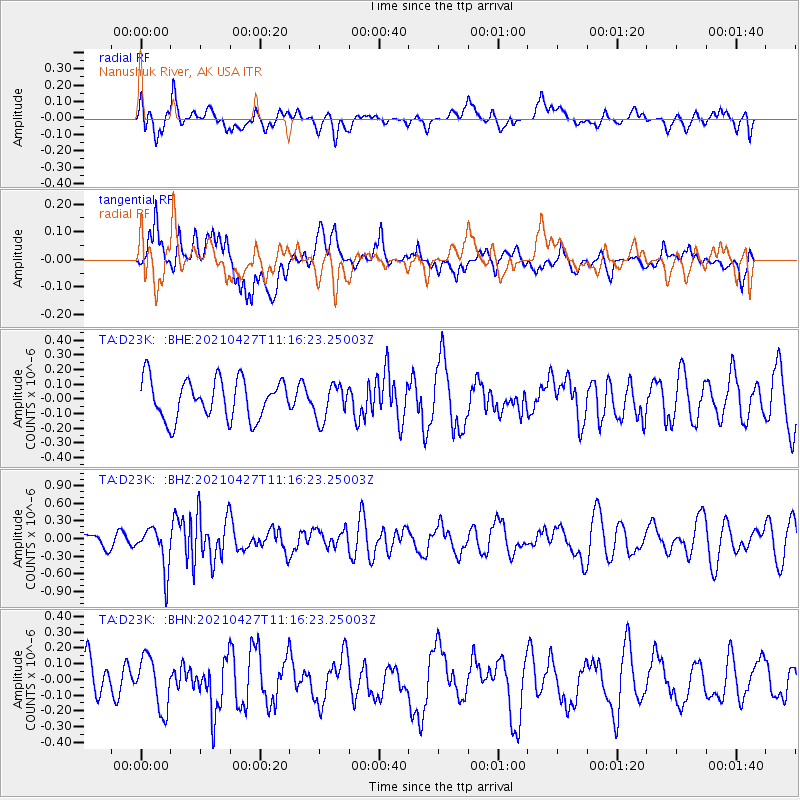
D23K Nanushuk River, AK USA - Earthquake Result Viewer
*The percent match for this event was below the threshold and hence no stack was calculated.
| Earthquake location: |
Near N Coast Of New Guinea, P.N.G. |
| Earthquake latitude/longitude: |
-3.4/145.7 |
| Earthquake time(UTC): |
2021/04/27 (117) 11:04:24 GMT |
| Earthquake Depth: |
10 km |
| Earthquake Magnitude: |
5.5 mww |
| Earthquake Catalog/Contributor: |
NEIC PDE/us |
|
| Network: |
TA USArray Transportable Network (new EarthScope stations) |
| Station: |
D23K Nanushuk River, AK USA |
| Lat/Lon: |
68.97 N/150.68 W |
| Elevation: |
406 m |
|
| Distance: |
84.0 deg |
| Az: |
18.984 deg |
| Baz: |
244.09 deg |
| Ray Param: |
$rayparam |
*The percent match for this event was below the threshold and hence was not used in the summary stack. |
|
| Radial Match: |
53.422035 % |
| Radial Bump: |
400 |
| Transverse Match: |
55.638046 % |
| Transverse Bump: |
400 |
| SOD ConfigId: |
24334971 |
| Insert Time: |
2021-05-11 11:13:45.321 +0000 |
| GWidth: |
2.5 |
| Max Bumps: |
400 |
| Tol: |
0.001 |
|
Signal To Noise
| Channel | StoN | STA | LTA |
| TA:D23K: :BHZ:20210427T11:16:23.25003Z | 2.708035 | 3.6165872E-7 | 1.3355024E-7 |
| TA:D23K: :BHN:20210427T11:16:23.25003Z | 1.932786 | 1.6522078E-7 | 8.548322E-8 |
| TA:D23K: :BHE:20210427T11:16:23.25003Z | 0.8949473 | 1.2107162E-7 | 1.3528351E-7 |
| Arrivals |
| Ps | |
| PpPs | |
| PsPs/PpSs | |


