You are here: Home > Network List > IU - Global Seismograph Network (GSN - IRIS/USGS) Stations List
> Station FURI Mt. Furi, Ethiopia > Earthquake Result Viewer
FURI Mt. Furi, Ethiopia - Earthquake Result Viewer
| Earthquake location: |
East Of South Sandwich Islands |
| Earthquake latitude/longitude: |
-59.0/-17.1 |
| Earthquake time(UTC): |
2017/11/15 (319) 02:02:25 GMT |
| Earthquake Depth: |
10 km |
| Earthquake Magnitude: |
5.6 Mww |
| Earthquake Catalog/Contributor: |
NEIC PDE/us |
|
| Network: |
IU Global Seismograph Network (GSN - IRIS/USGS) |
| Station: |
FURI Mt. Furi, Ethiopia |
| Lat/Lon: |
8.90 N/38.68 E |
| Elevation: |
2570 m |
|
| Distance: |
81.0 deg |
| Az: |
55.811 deg |
| Baz: |
205.651 deg |
| Ray Param: |
0.04787147 |
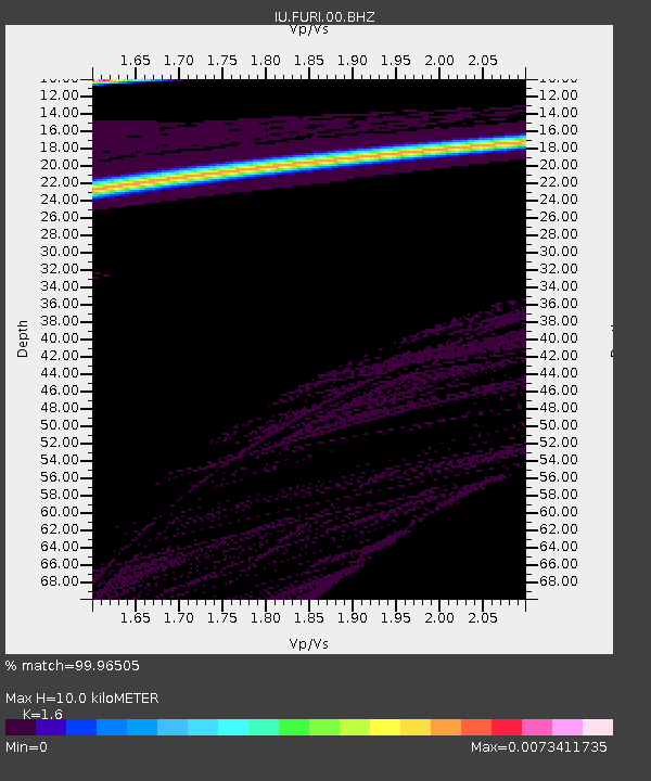
| Estimated Moho Depth: |
10.0 km |
| Estimated Crust Vp/Vs: |
1.60 |
| Assumed Crust Vp: |
6.464 km/s |
| Estimated Crust Vs: |
4.04 km/s |
| Estimated Crust Poisson's Ratio: |
0.18 |
|
| Radial Match: |
99.96505 % |
| Radial Bump: |
7 |
| Transverse Match: |
99.9791 % |
| Transverse Bump: |
5 |
| SOD ConfigId: |
2429771 |
| Insert Time: |
2017-11-29 04:57:14.088 +0000 |
| GWidth: |
2.5 |
| Max Bumps: |
400 |
| Tol: |
0.001 |
|
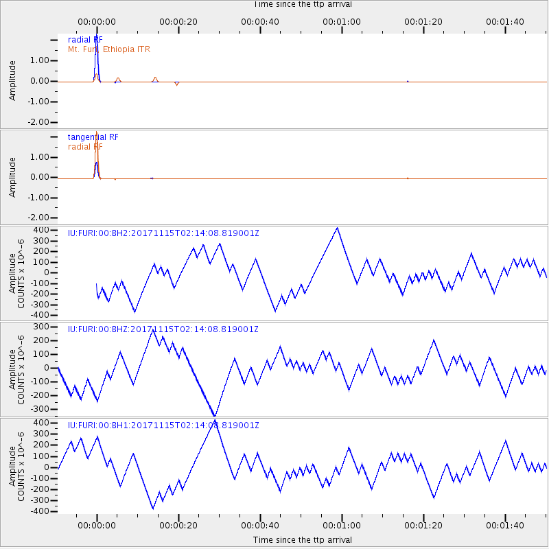
Signal To Noise
| Channel | StoN | STA | LTA |
| IU:FURI:00:BHZ:20171115T02:14:08.819001Z | 1.5344504 | 1.8044404E-4 | 1.1759522E-4 |
| IU:FURI:00:BH1:20171115T02:14:08.819001Z | 1.5115787 | 2.1633506E-4 | 1.4311861E-4 |
| IU:FURI:00:BH2:20171115T02:14:08.819001Z | 1.5234087 | 2.191364E-4 | 1.438461E-4 |
| Arrivals |
| Ps | 1.0 SECOND |
| PpPs | 3.9 SECOND |
| PsPs/PpSs | 4.9 SECOND |


