You are here: Home > Network List > AE - Arizona Broadband Seismic Network Stations List
> Station BARN Flagstaff > Earthquake Result Viewer
BARN Flagstaff - Earthquake Result Viewer
| Earthquake location: |
Kermadec Islands Region |
| Earthquake latitude/longitude: |
-29.2/-176.8 |
| Earthquake time(UTC): |
2021/04/27 (117) 16:33:33 GMT |
| Earthquake Depth: |
10 km |
| Earthquake Magnitude: |
5.9 mww |
| Earthquake Catalog/Contributor: |
NEIC PDE/us |
|
| Network: |
AE Arizona Broadband Seismic Network |
| Station: |
BARN Flagstaff |
| Lat/Lon: |
35.28 N/111.74 W |
| Elevation: |
2254 m |
|
| Distance: |
88.7 deg |
| Az: |
47.92 deg |
| Baz: |
232.475 deg |
| Ray Param: |
0.042375192 |
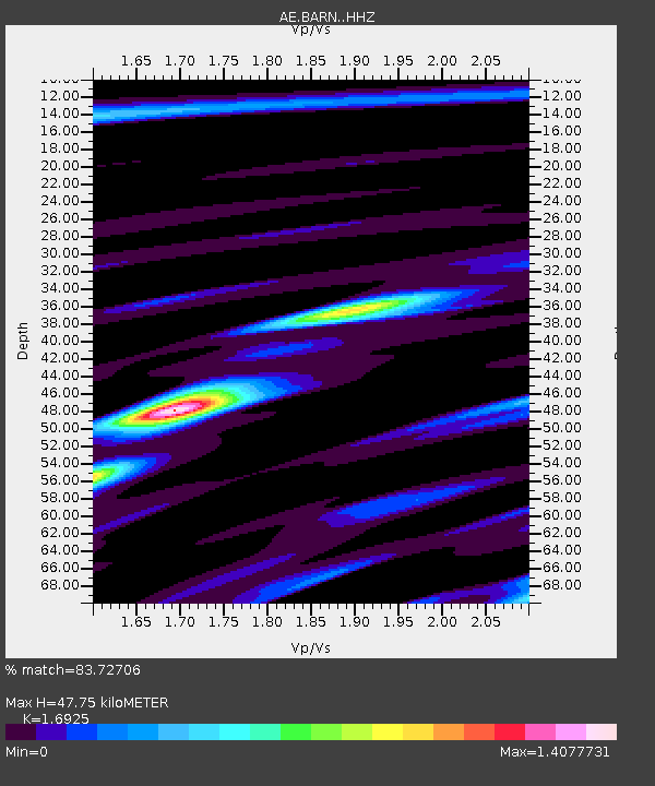
| Estimated Moho Depth: |
47.75 km |
| Estimated Crust Vp/Vs: |
1.69 |
| Assumed Crust Vp: |
6.207 km/s |
| Estimated Crust Vs: |
3.667 km/s |
| Estimated Crust Poisson's Ratio: |
0.23 |
|
| Radial Match: |
83.72706 % |
| Radial Bump: |
400 |
| Transverse Match: |
65.14704 % |
| Transverse Bump: |
400 |
| SOD ConfigId: |
24334971 |
| Insert Time: |
2021-05-11 16:36:12.759 +0000 |
| GWidth: |
2.5 |
| Max Bumps: |
400 |
| Tol: |
0.001 |
|

Signal To Noise
| Channel | StoN | STA | LTA |
| AE:BARN: :HHZ:20210427T16:45:55.71997Z | 3.2441113 | 2.0289076E-7 | 6.254125E-8 |
| AE:BARN: :HHN:20210427T16:45:55.71997Z | 1.254876 | 8.61859E-8 | 6.8680805E-8 |
| AE:BARN: :HHE:20210427T16:45:55.71997Z | 0.6332431 | 4.0798476E-8 | 6.442783E-8 |
| Arrivals |
| Ps | 5.4 SECOND |
| PpPs | 20 SECOND |
| PsPs/PpSs | 26 SECOND |


