You are here: Home > Network List > CI - Caltech Regional Seismic Network Stations List
> Station GLA Glamis, Glamis, CA, USA > Earthquake Result Viewer
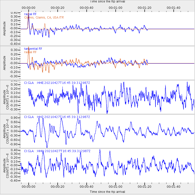
GLA Glamis, Glamis, CA, USA - Earthquake Result Viewer
*The percent match for this event was below the threshold and hence no stack was calculated.
| Earthquake location: |
Kermadec Islands Region |
| Earthquake latitude/longitude: |
-29.2/-176.8 |
| Earthquake time(UTC): |
2021/04/27 (117) 16:33:33 GMT |
| Earthquake Depth: |
10 km |
| Earthquake Magnitude: |
5.9 mww |
| Earthquake Catalog/Contributor: |
NEIC PDE/us |
|
| Network: |
CI Caltech Regional Seismic Network |
| Station: |
GLA Glamis, Glamis, CA, USA |
| Lat/Lon: |
33.05 N/114.83 W |
| Elevation: |
610 m |
|
| Distance: |
85.3 deg |
| Az: |
48.068 deg |
| Baz: |
230.754 deg |
| Ray Param: |
$rayparam |
*The percent match for this event was below the threshold and hence was not used in the summary stack. |
|
| Radial Match: |
67.95988 % |
| Radial Bump: |
400 |
| Transverse Match: |
55.65558 % |
| Transverse Bump: |
400 |
| SOD ConfigId: |
24334971 |
| Insert Time: |
2021-05-11 16:40:55.186 +0000 |
| GWidth: |
2.5 |
| Max Bumps: |
400 |
| Tol: |
0.001 |
|
Signal To Noise
| Channel | StoN | STA | LTA |
| CI:GLA: :HHZ:20210427T16:45:39.312987Z | 2.9326415 | 2.6856364E-7 | 9.157738E-8 |
| CI:GLA: :HHN:20210427T16:45:39.312987Z | 0.8414998 | 1.3424626E-7 | 1.5953214E-7 |
| CI:GLA: :HHE:20210427T16:45:39.312987Z | 1.4854375 | 1.4551986E-7 | 9.796432E-8 |
| Arrivals |
| Ps | |
| PpPs | |
| PsPs/PpSs | |


