You are here: Home > Network List > NN - Western Great Basin/Eastern Sierra Nevada Stations List
> Station ZPR Zephyr Cove, Lake Tahoe, Nevada > Earthquake Result Viewer
ZPR Zephyr Cove, Lake Tahoe, Nevada - Earthquake Result Viewer
| Earthquake location: |
Kermadec Islands Region |
| Earthquake latitude/longitude: |
-29.2/-176.8 |
| Earthquake time(UTC): |
2021/04/27 (117) 16:33:33 GMT |
| Earthquake Depth: |
10 km |
| Earthquake Magnitude: |
5.9 mww |
| Earthquake Catalog/Contributor: |
NEIC PDE/us |
|
| Network: |
NN Western Great Basin/Eastern Sierra Nevada |
| Station: |
ZPR Zephyr Cove, Lake Tahoe, Nevada |
| Lat/Lon: |
39.01 N/119.94 W |
| Elevation: |
2001 m |
|
| Distance: |
86.1 deg |
| Az: |
40.843 deg |
| Baz: |
227.216 deg |
| Ray Param: |
0.044289596 |
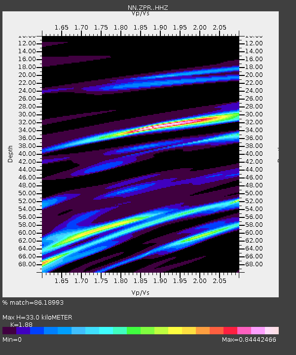
| Estimated Moho Depth: |
33.0 km |
| Estimated Crust Vp/Vs: |
1.88 |
| Assumed Crust Vp: |
6.279 km/s |
| Estimated Crust Vs: |
3.34 km/s |
| Estimated Crust Poisson's Ratio: |
0.30 |
|
| Radial Match: |
86.18993 % |
| Radial Bump: |
343 |
| Transverse Match: |
97.15874 % |
| Transverse Bump: |
137 |
| SOD ConfigId: |
24334971 |
| Insert Time: |
2021-05-11 16:44:34.130 +0000 |
| GWidth: |
2.5 |
| Max Bumps: |
400 |
| Tol: |
0.001 |
|

Signal To Noise
| Channel | StoN | STA | LTA |
| NN:ZPR: :HHZ:20210427T16:45:43.158019Z | 1.9091285 | 1.5151697E-7 | 7.936446E-8 |
| NN:ZPR: :HHN:20210427T16:45:43.158019Z | 1.7240617 | 1.8827356E-7 | 1.092035E-7 |
| NN:ZPR: :HHE:20210427T16:45:43.158019Z | 0.8815196 | 1.1221633E-7 | 1.2729873E-7 |
| Arrivals |
| Ps | 4.7 SECOND |
| PpPs | 15 SECOND |
| PsPs/PpSs | 20 SECOND |


